With the OpenStreetMap spatial dataset of the world, and the excellent map rendering toolkit Mapnik, it’s quite straightforward to make theme-based maps, such as OpenCycleMap, OpenPisteMap, OpenHikingMap and OpenWhitewaterMap.
All very well, but what about orienteering maps? So, here is OpenOrienteeringMap. For the moment, it just covers the UK, but there’s no particular reason why this couldn’t be extended to cover the world (except that the postcode-finder only works in the UK). [Update – it now covers almost the whole world!]
The map is created on-the-fly, using a process developed by the OSM community that I’ve built on for my day job at UCL. The map is created on a quite fast computer, but because it is created on-demand for areas people haven’t visited before, it may run slow if a few people are looking at it at once – and you’ll need a fast internet connection as the map is delivered as PNGs.
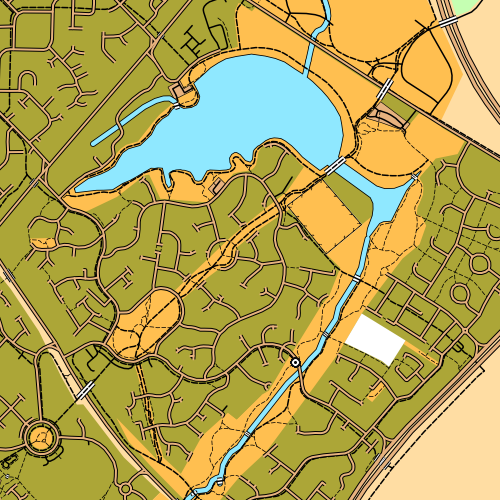
There are two styles – Street-O and Pseud-O.
Street-O
This attempts to recreate the “minimalistic” feel of street-O maps, as used for informal street events in London by the central clubs SLOW and LOK, and in other areas around the UK. Only roads, tracks, paths, rivers/lakes and railways are shown, the maps are high-contrast (black on white) and have little colour. The few colours that are on the map – for major roads and water features – are the “official” ISOM standard colours for these features.
OpenStreetMap data has been used for one street-O before – my Bow race in September, although here the data was pulled into Quantum GIS and a vector-based PDF was produced, allowing maps to be printed at high resolution.
Pseud-O
This is a less standard but richer map. It uses many more features in the OSM data, where they correspond to regular orienteering features. OSM data, for ~99.999% of areas, is not detailed enough to correspond to that on an ISOM map, but it might be sufficient for basic urban orienteering events in a few places, or the odd trail challenge. As the OpenStreetMap dataset continues to be added to and enhanced by its contributors, so the orienteering map will increase in complexity and accuracy. Again, the colours are as officially defined in ISOM. For now, it’s fun to look at the whole of the UK with the ISOM look-and-feel, but let’s not run any serious events with the map! (More on ISOM orienteering maps and OSM.)
The postcode finder uses the c. 70000 postcodes supplied by NPEMap (with contributions from FreeThePostCode and the postbox locator project) so should get you to within a mile or two of where you want to be, in urban areas.
Explore the map and let me know about any big problems with the cartography or functionality via the comments here. I’m not interested in missing data complaints for an area though – OSM is a project produced by the efforts of volunteers, so if your area is blank, it’s because there isn’t an interested local. So go and map the area yourself, and add it to OpenStreetMap so the whole world benefits (and let me know so I pull in the updated dataset!)
More information about how the map is made is here.
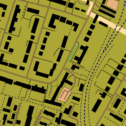
Top: Good to see the efforts of the Milton Keynes mapping party I organised in May make it to an orienteering map. Upper Middle: Edinburgh’s Old Town. Lower Middle: Shotover Wood, near Oxford. Bottom: Great detail in Putney, thanks to an enthusiastic local contributor in the area.
50 replies on “OpenOrienteeringMap”
[…] Any donations will be distributed between me as primary maintainer/developer, Stephen (to contribute towards his hosting costs) and Oliver (to recognise his founding of oomap and development over 12 years). […]
[…] /2009/12/oom/ […]
I recently noted that areas marked as soccer fields etc translate into open orienteering as fenced enclosures.
I hahe recently noticed that fences and walls BOTH translate into walls.
fooball (soccer) fields in OpenStreetmap are all shown as fenced areas in OpenOrienteeringMaps and are very rarely so .
Hi Ollie. I’m trying to zoom in on New Malden (KT3 3BP) on the new version to plan a Street O. But beyond a certain point the view goes to contours only. Not q sure why, have not had this problem before in running off trial maps. thanks, Andrew (SLOW member)
Hi Andrew, that sounds very odd, I’ve just tested with that postcode now and it looks like the full map is showing OK for me. Could you let me know an example map number (as shown for when you click Save & get PDF map) which is showing this problem?
Is the site broken – can’t seem to get any maps when I zoom in?
Hi James – yes the tiling/PDF server was down on the afternoon of 4 June – the web server, which is used for other things too, had some configuration issues. Should be all fine now.
Hi
I’ve used OOM alot in Sweden, but since the new release I can’t get the pseudo-omap to work in sweden. (the new version apperas “locked” to UK) and in the old version the pseudo-omap will not load. (i only get a pink background)
Am I doing something wrong?
Will Sweden be available in the new version soon?
Hi Anders. OOM is UK only at the moment but I’m hoping to put it out again in some other countries some time – it’s dependent on me getting the time to set up the appropriate database tables and UI!
Also hoping that world-wide coverage of oom returns on one day.
[…] OpenOrienteeringMap (tags: openstreetmap maps walking) […]
Christopher – see /2010/03/oom-undocumented-feature-rotating-control-labels/
Alternatively I would be delighted to offer you your money back!
It is not possible to move the control numbers – to prevent their superimposition on other control circles. We therefore want to place control circles ONLY – and will write in the control numbers by hand.
However where the programme sees no control number it writes NaN on the map – which clutters the page and makes it even less readable.
It would be easier to do the whole job by hand!
Jens – I’ve just tested, it is working for me OK. When you press the final “OK”, a PDF called oom.pdf should be downloaded automatically to your computer. Do try with another browser, e.g. Firefox, if it’s not working for you still.
Hi
Great map and funktions – but the Creat-PDF does not work at the moment. To bad, I use the created map in local school education.
Hope it will work soon.
/Jens Winbladh
Robert – mark it as access=private or access=no on OSM. Unfortunately it may still show up in OOM – I need to address that, but sometimes access=no is intended for cars. I would just screen it out on an OOM map, for now.
OpenOrienteeringMap is a brilliant innovation to help in the production of maps for Street-O. I have recently run on several maps derived from it, where suitable maps were not previously available.
For over 25 years I have maintained a Street-O map of my own town (Stourbridge, UK) initially on paper, more recently in ocad, and have started updating OpenStreetMap. I see an immediate question with Service Roads. Hitherto, my convention has been “if you can run on it, I show it”. Specifically, some service roads into the train station car park are (in my view) OK, but there is a particular service road into the same car park which is gated at both ends and access is prohibited. It exists on the ground, but would be most undesirable on a Street-O Map. My inclination is to delete it from OpenStreetMap, but I wonder if there is a convention covering this point?
Adrian – NaN is Not a Number – sounds like you are entering something letters, full stops, spaces or other non-numeric characters into the control numbers box.
Used this for my event in Birmingham – thanks! Just now trying out the add-controls feature for the first time, the controls have NaN next to them on the pdf. Not sure what that’s about.
thanks, I deeply appreciate your work and the fact that you also made the map server available worldwide 🙂
Hey, I noticed that Walls and fences are rendered incorrectly in a pdf map (they are fine – though the same – while browsing in pseud-O mode). They both get replaced with a VERY large black texture.
Example:
http://yfrog.com/jvoomrenderp
This is truly amazing and will save me months of work. I am planning a night street event next February in Horsham for Southdowns and want to try it out with some scouts before then.
It looks like somebody is adding buildings from my end of town. I will review the map and update OSM accordingly
Cheers
Hello!
Wonderful work! But (it’s always something) I’ve noticed that fences and stonewalls are rendered the same (as walls).
Hi
This is a great service, can’t wait to get my neighbourhood mapped.
I found a couple of flaws:
1. waterway = ditch doesn’t get rendered
2. natural = stone , also not rendered
Internal server error, when I was creating a map near Hänichen in Germany with the Name “Hänichen”. The same procedure with the Name “Haenichen” was ok.
Richard – putting in such a reprojection would be tricky (I’m not sure if there even is a projection that always has magnetic north as the vertical direction.) A rotation would also be difficult to do, I’m not sure if such a feature is available in the Cairo PDFSurface library.
walley/h: Both are bugs, thanks, noted.
Peter – Good spot, I hadn’t noticed this. For some reason, applying both the PolygonSymbolizer (to colour the area yellow) and the LinePatternSymbolizer (to add the fence with tick-marks) results in the latter not appearing on the PDFs. This is actually a blessing, as Mapnik doesn’t not yet support vector patterns, and the fence marks look very odd when they do appear on the PDF. As a workaround, I’ve changed the symbol to be a solid black line.
while generationg a pseudo-o map pdf, the fences are not in the pdf.
i tried it with the following map:
http://www.oobrien.com/oom/?zoom=16&lat=52.527&lon=13.43441&layers=B00FTFFFFF
thanks!
bug: river under terrain (tunnel=yes) is render like normal river.
area=yes is not rendered
I have compared a few of our maps to what comes up. Very impressed some of our areas are well documented already. Would it be possible to get the maps to display aligned to magnetic north, it appears that they are true north at present. This shows up very clearly when I flick between OCAD and the web page. Even if we had to type in the declination that would be fine. e.g. we use 23.5 degrees in Christchurch NZ.
Great functionality. Thanks very much. Christchurch in New Zealand is well documented in OSM so this looks very interesting for our local O club.
Thanks Sam – 8.5×11 pages (i.e. US Letter) is now available as an option on the PDF creator.
The creator is designed for orienteering maps rather than for other layer types. A general-use PDF creator is something I could build in the future if there was demand. I wouldn’t be able to do the cycle map as the stylesheet for that layer isn’t published (for good reasons, it’s Andy’s intellectual property) so I wouldn’t be able to recreate it in vector format, and raster-based PDFs are not good for maps. The default “mapnik” layer is certainly possible to do though as that stylesheet is in the OSM SVN repository.
I don’t know if the hikebikemap.de stylesheet is published, but even if it is, the use of raster layers (for the background hillshading) adds a layer of complexity to the process.
IJ – dashed lines are the convention for street-O maps. For the pseud-O layer, metalled cycle ways should perhaps be shown as unbroken lines – something that may change in the future.
Thanks for this, it is really really good!
Hi,
Awesome Site!
Wondering if your planning on having a ‘hikebikemap.de’ layer and a ‘cyclemap layer’ and a mapnik layer.
How you have that pdf creater is AWESOME!
Would be great if you could make regular 8.5×11 pages also.
Thats all for my wish list.
Great Job!
Cheers,
Sam
Wow! Especially the Pseud-O is really good-looking and makes me wanna go straight out and map my surroundings even more. Also very nice with a pdf-exporter well suited for printed maps. This is really cool! Keep up the good work!
I feel it to be slightly strange that cycle/footways appear as paths (dashed lines), esp. if they are paved they are hardly any different from serviceway which are the only ones that are currently drawn with a solid line.
I have created a page on the OSM wiki about OOM: http://wiki.openstreetmap.org/wiki/OpenOrienteeringMap
Next step is to populate that page with pictures. 🙂
OOM is a beautiful thing. I’ve been adding details in OpenStreetMap for my part of the world and looking forward to seeing them rendered in OOM.
Thanks!
Sam – I would be wary of adding a KML export, as it would likely strain the server a lot – the tiles are generated on-the-fly and I would image Google Earth would be more aggressive at pulling in the content than a simple web-page.
Peter – The OCAD file format looks seriously scary to export to, however I think OCAD can export PDF and/or SVG, and, as Mapnik has built-in PDF and SVG rendering support, I’m hoping to have the capability to download maps in one of these two formats soon.
hey,
good work!
it would be nice to export some parts as ocad-files;)
why don’t you take a domain like OpenOrienteeringMap [dot]net ? i think its a good project, where its a good thing to have a domain.
best greetings
peter
Wow, awesome map!
Cool to see that the world is available 🙂
I dont know what you need todo at your end, but it would be GREAT to see this map available as a Google Earth KML overlay.
http://www.mgmaps.com/kml/
Currently it’s the base Mapnik/Osmarender/Cyclemap
I dont know what the author does to make it work… but its great to see it.
Your map is great because it DOESNT show the amenties. This way, we can use it to create our own tourist/theme maps and are able to draw on top of the map, so to highlight the specific amenities that our map is for. Ie. a map showing walking routes doesnt need to show all the post boxes.
Great work,
Sam Vekemans
Across Canada Trails
Brian, Martin – OOM now covers the whole world. Also, the data has been updated to January 6th.
Yes, I am hoping to expand OOM to other countries – I’ll have to see how long it takes to import and whether it affects performance.
Great work! Any way to add data for other countries? I would love to see a Pseud-O map for my area (Germany, city of Karlsruhe). Since OSM is very detailed here already, this should give quite a nice start for a simple sprint race. Also, the city is mostly flat anyway, so missing contours are no problem.
Steve – good spot. I should be able to fix it by layering tram-lines underneath roads, while keeping railways above them (in the absence of specific layering information for the features concerned).
Those StreetO maps will save a lot of time.
The only problem that I could see (apart from OSM data errors) was with tram routes eg. Sheffield (S1 1AA) and Croydon (CR1 1AA) .
Where the tram shares the road with traffic only the railway symbol is shown. Not sure how you solve this without using a new symbol.
I certainly hope to get Ireland and the Isle of Man in to the database and so into OOM, soon.
Fascinating. Have been an OSM mapper for two years and am also an O mapper with Ocad. Would be delighted to see to see parts, if not all, of Ireland included in the dataset. Particularly http://www.openstreetmap.org/?lat=53.3432&lon=-6.43949&zoom=15&layers=0B00FTF and http://www.openstreetmap.org/?lat=53.2336&lon=-6.2311&zoom=12&layers=0B00FTF .Did some mapping in North Wales and Leicester as well and these look Great in OOM. Well done at pushing the frontiers of OSM. Regards
Brain
[…] details of the construction are in a posting and information page on my personal […]