Categories
Notes Orienteering

Orienteering, Inspired by London 2012?

Orienteering is not an Olympic sport, it is however a grassroots activity which just happens to have a number of venues (some existing, some potential) close to the site of the 2012 London Olympics. As such, the sport of orienteering could benefit from any increase in interest in sports in this part of east London, caused by the approaching Games.

london2012orienteering

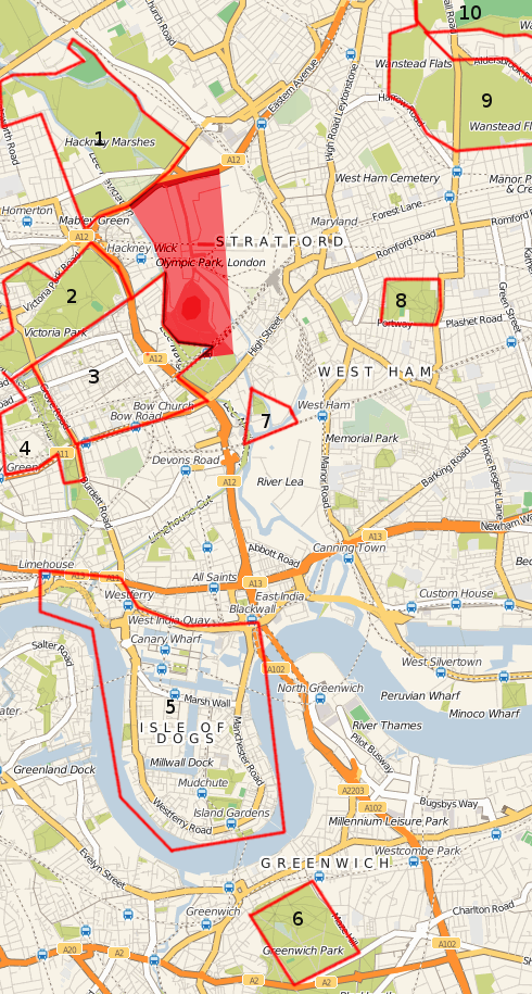
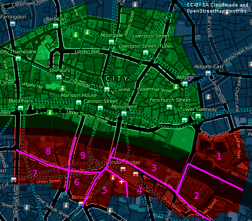
The above map (basemap by Cloudmade, based on OpenStreetMap data) shows existing and possible venues for orienteering events around the Olympic Park site which is shaded in red:

  1. Hackney Marshes and Mabley Green. A very large (400 acre) venue, although not particularly interesting – essentially football pitches as far as the eye can see. However, there is enough of interest for a local event, particularly if the two parks on the west side of the Lee Navigation are included. A hidden gem just in the south part is Wick Woodland, a proper, dense wood with a maze of paths. Sadly, the Waterworks Nature Reserve, just to the north of the marked area, is likely to be out-of-bounds. I believe LOK have an old black-and-white map of the main part of the marshes, from the eighties. The East Marsh is due to be tarmacked over and turned into a giant car park for the Games themselves.
  2. Victoria Park is another large (200 acre) green area, LOK mapped it many years ago and it was used quite regularly for events, up to around 10 years ago. I understand they are about to re-map it and it will hopefully be used for an event next summer.
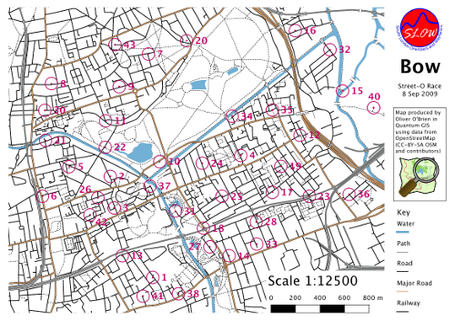
  3. Bow – this area was first used for a Street-O race in Septemberevent results.
  4. Queen Mary and Mile End Park was used for a SLOW park race in 2008. The campus area is small but allows for exciting sprint racing, the park is also narrow but has some interesting features. A new bridge across the Regent’s Canal has just opened, which will allow the map to be expanded for a similar race in the future.
  5. The Isle of Dogs including Canary Wharf and Limehouse – this is an aspiration, no orienteering map exists yet, and organising a race here would be a huge logistical challenge, but this would make a super area for a city race, possibly in 2011 or 2012.
  6. Greenwich Park – DFOK have created an orienteering map of this hilly 180 acre royal park, which is also a venue for the 2012 Olympics. It was used for an event in March, and there will be another one in April 2010.
  7. Lea River Park – at the moment, the useable area – Three Mills Green and the House Mill – is possibly too small even for the smallest event, and there is no existing map. However, the surrounding area is due to be developed into various new parks over the next six years, so a map of this area could grow with the developments.
  8. West Ham Park – quite small (80 acres), but pleasant, could probably sustain a small summer park race. Not yet mapped for orienteering.
  9. Wanstead Flats – a large, but very flat and simple area, unfortunately split up into three sections by two busy roads. Already mapped by CHIG.
  10. Wanstead Park – a ruined, historic estate, very dense vegetation in places, but used by CHIG fairly regularly for summer events – would possibly be more suited for winter events due to the extent of the vegetation growth!

Also:

  • Regent’s Park (LOK) – not on the map here. Newly mapped by LOK, they are keen to stage an event in this royal park which will also be a venue for the London Olympics.
  • The Olympic Park itself. Much of it will become available to the public, and therefore potentially for orienteering, in summer 2013.

No orienteering club is based in the East End – indeed, London’s four orienteering clubs sort of converge on this point. London OK (LOK) is based around Hampstead and is generally active in London’s north-west quadrant. Chigwell OC (CHIG) is based around Epping Forest in the north-east. Dartford OK (DFOK) generally runs events in the south-east of the capital. Finally, South London OW (SLOW) is mainly based in the south-west, around Wimbledon and Kingston. There are a couple of SLOW maps in the East End – but only because I live there and have created them!

This means that a collaboration between the four clubs would make sense, for any London 2012-themed series planned for the future.

Categories
Orienteering

The Amazing Maze

Maize Maze-O

I ran in a rather unusual orienteering event yesterday – a maze cut in a field of maize. It was the Maize Maze-O Challenge, taking place at the National Forest Maize Maze in the Midlands and organised by Stodgetta of WCH. I’d never heard of maize mazes before, but there are several throughout England. They generally have a new design each year, the crop is planted, the pathways have their crop removed, the field grows and the maize appears, before being cut down for animal feed at the beginning of October.

maizegps

The format of the race was two qualifying runs, both less than a kilometre straight-line but well over 2km by the shortest path. These were in the afternoon, there was then a pause while the sun went down (and the competitors took advantage of the local catering – burgers from cows fed on last year’s maize) and then the finals – in the dark! A first at night-orienteering for me, but I just about made it around, along with around 100 other connoisseurs of unusual orienteering races!

Mike G enters the maze for the night final.

The map and pic (of Mike G from SLOW entering the maize maze for the night final) is on the WCH website. The GPS trace is of my night final route.

Categories
Orienteering

City Race Redux

So, SLOW had the second City of London race on September 12th. I extended the map west to encompass the Temple and Holborn areas, but left the planning to Alan L, who produced excellent courses that caught out a lot of people. The race was a great success with around 500 competitors this year (up 25% on the previous race) and again some lovely sunshine. The assembly was in the shadow of St Paul’s Cathedral this year which added a certain “wow” factor. ClifBar again sponsored the race, giving finishers a tasty snack as they crossed the finishing line.

See the planner’s comments for the full details of what unfolded – there were some minor problems but few people had their run impacted significantly by them. Roll on next year!

Here’s the layers that were brought together to produce the map (once again, in Adobe Illustrator CS3) – from the top down, they are:

  • The course – this layer was produced by the planner, Alan, supplied in EPS format and placed as a top layer.
  • The adornments, including the title, logo and scale.
  • The north lines.
  • Tunnel walls.
  • Point features – mainly trees and statues.
  • Buildings. The most important layer.
  • Construction sites. Mercifully few of these in the new west part of the map.
  • Walls, fences and other barriers. Quite difficult for orienteers to spot sometimes!
  • Out-of-bounds-areas – the largest one is Lincoln’s Inn.
  • Water, including of course the River Thames.
  • Steps and path boundary lines.
  • Underpasses and canopies. The cartography for these may be tweaked for next year.
  • Vegetation, including the few small parks and open spaces in the City.
  • Pavement boundaries for the major roads on the map.
  • And finally the road colour, which lies under everything else.

colmaplayers

Categories
Orienteering

Going South of the River

Here’s my planned mapping for the next extension to the City of London orienteering map:

extension2010

The plan is to do one of the nine sectors every three weeks between January and June next year.

The sectors are:

  1. St Katherine’s Docks
  2. Shad Thames
  3. Pool of London
  4. London Bridge Station
  5. Guy’s Hospital
  6. Borough
  7. Southwark
  8. Bankside
  9. Borough Market
Categories
Orienteering

Going back, Wayback

Now that I’ve taken on maintaining the SLOW website, I’ve been digging around the myriad of directories in the site, and elsewhere on the web, to find out the history of the site. The site itself generally only has information going back as far as 2005, there certainly was a website before then, but malware attacks and space constraints mean the older content has been long deleted. I’ve only been in the club since 2003, so had no idea what it was like before.

The Internet Archive’s Wayback Machine is, as ever, a treasure trove of old content. Through it, I’ve found versions of the website going back as far as 1996 – which means, slightly annoyingly, it predates my own website by a year. It’s changed web address several times, although it’s been at sloweb.org.uk since 2002 [Update: and slow.org.uk since 2014.] The current design dates from as late as 2007, although the current logo debuted in late 2004.

Some highlights:

Here’s a version of the club’s logo from the last century:

slow

Through the digging, I’ve discovered two older versions of SLOWprint, the club newsletter – issues 116 and 122, from 1997 and 1998. I’m pretty sure that these are the oldest on the web. The club has been around for several decades though, and there’s over 100 issues of SLOWprint not online – a project for a future club archivist, maybe.

Here’s the logo for the 1998 Southern Express series of orienteering events in (the series started in 1996 and has ceased only quite recently), which amused me a little bit:

sxo

The OK Nuts pages from 1996 are amongst the earliest I could find – they include this quote at the top:

Welcome to SLOW’s first web site for information about Orienteering. It is an experiment, so please bear with us as we try e-mail entry, the map, advance details and results. This has tremendous potential so I hope you support this venture. Any comments will be gratefully received. The site will run from November until the end of December.

Remember the foot-and-mouth crisis back in 2001? It decimated the orienteering season.

Street-O races have been going on for longer than I thought – here’s a mention of one back in Richmond back in 1998.

ASTROFEATURE sounds like something we could definitely do with in Clapham Common or some of our other “feature-light” areas.

Here’s a link to the pages from 1997-9.

Categories
Orienteering

Orienteering on the Fourth Plinth – One and Other O

Orienteering will have its hour of fame tomorrow at 1pm, Trafalgar Square in Central London. Dadge will be up on the fourth plinth, as part of Anthony Gormley’s live art project, doing a very small orienteering course. There will be other courses in the main part of the square at the same time.

A special map has been produced for the occasion, 1:1500 in full colour on a postcard, with details of other orienteering in London on the back. Be there at 1pm to pick up your postcard and take part in some mass participation art.

Have a look at the NopeSport article for more.

Categories
OpenStreetMap Orienteering

Bow Street Race

I organised a street orienteering event last night in Bow, East London. It was the first race of this season’s SLOW Street-O series. Nearly 40 people came along and survived the mean streets of Bow in soaring temperatures – it was nearly the hottest day of the year.

When producing the map for the race, I wanted to do something different – I wanted to finally utilise my GIS/OSM based method that I developed in my MSc dissertation last year. So, the map was based *entirely* on OpenStreetMap data, and produced in a GIS rather than a cartography or graphics package. Nothing was added to the map that isn’t in the OpenStreetMap database, so future street orienteering maps of the area that use the same technique will be at least as good, or better, as the wider OSM community continues to improve the mapping of the areas.

bowmap

The GIS used was Quantum GIS. I used a pre-release version, 1.2.0, although the current “unstable” 1.1.0 release should work the same for these purposes. A patch was applied, to cap the ends of thick line strokes to the true extent of the line, rather than them extending slightly out which is the default.

During the creation of the map (which was in Quantum GIS’s buggy but full-featured Print Composer function) I created a number of style templates, representing standard street orienteering map symbology. I hope to have these available for download soon.

The process in creating the map was:

  • Friday – investigating how complete and accurate the OpenStreetMap data of the area is, by comparing with satellite imagery and other sources.
  • Saturday and Sunday afternoons – two long and windy cycles through various housing estates and down alleyways and streets, to record GPS tracks of missing streets.
  • Saturday and Sunday evenings – adding in the detail to the OSM database, based on the GPS data and my notes. Also building Quantum GIS.
  • Monday afternoon – identifying possible locations for controls.
  • Monday early evening – a cycle around half the control points to confirm the questions and answers.
  • Monday late evening – creating, styling and adorning the draft map in Quantum GIS.
  • Tuesday morning – cycling around the remaining control points.
  • Tuesday lunchtime – assembling the final map, checking for any generalisation needed, fine-tuning the control location “dots” and printing.
  • Tuesday evening – the race!

You can download the vector-based PDF of the map here (1MB), and the questions here if you fancy doing the race in your own time (or virtually on Google Street View – many of the answers are visible on it.)

Comments from runners were generally positive – one spotted a road that wasn’t accessible, and the 1:12500 scale made the map quite cluttered. One key underpass under a railway was missed by someone. The simple cartography in Quantum GIS means, for example, black dashed lines can’t be forced to have a black segment at each end. There were more issues with interpretations of the questions than with the map itself.

No one got all of the controls in the hour, and they weren’t supposed to – with 41 controls spread right across the map, this would have been impossible to do. The top score was 550 points, out of a maximum of 800.

Categories
OpenStreetMap Orienteering

How to cycle for 25 miles without leaving the neighborhood

Here’s the GPS trace for a bike ride I did on Saturday:

capture

It’s 25 miles long, but never I’m never more than a mile from the Bow Wharf complex.

Why? I’m organising a street orienteering race (“Street-O”) for Tuesday evening, and the map will be based entirely on OpenStreetMap data – probably the first time OSM data has been used for an orienteering map for a real race.

The cycle was to find as many missing roads, paths and alleyways as possible to try and make the map complete. Bow has a large number of social housing estates and some of these are a real rabbit warren of alleys.

The ways were then drawn in to the map, using Potlatch, and then the data was downloaded, converted using the script I developed for my MSc dissertation last year, and added into a custom build of Quantum GIS. The map was then “composed”, with adornments (scale bar, legend) added, and a PDF created. Because it’s a GIS, the map already knows its scale and the colours used in its symbology, so adding the scale bar and legend is just a case of selecting the area of the map you want the adornment to go on. Quantum GIS’s cartography isn’t perfect though – line capping is problematic, but it will do for tomorrow’s purposes.

The result will be seen, and hopefully used, by everyone who turns up for the event at the Royal Inn on the Park tomorrow evening. Come along if you can! The weather is looking good.

It’s good to finally put into practice the technique I outlined in the dissertation. I will post a couple of excerpts soon to this blog – namely the bits of the dissertation I referred to when creating the final map last night.

Categories
Orienteering

Here come the Vets

Entries for the second City of London orienteering race, next Saturday, are rocketing. We have over 10% more pre-entries last year, and the regular-rate entries have now closed (late entries are open until next Wednesday.)

What’s interesting about the entry this year is the demographics have shifted somewhat.

Here’s a couple of graphs showing the breakdown by class for the two years – MO = Men’s Open, MV = Men’s Vets (40-55) WSV = Women’s Super Vets (55+), and so on.

2008

2009

The open classes are roughly the same as last year – it’s Men’s and Women’s Vets (MV/WV) and the Men’s Super Vets (MSV) that have shot up in terms of entry numbers – and there’s a lot more “new to orienteering” entrants – rougly corresponding to the green parts of the bars – in these categories.

In terms of international entries, we have roughly the same proportion as last year – about 7%. The proportion of beginners (effectively those that haven’t bought their own SI cards) has dropped slightly from 23% to 18%.

The map and courses are being tweaked and polished, before going off to the printers early next week. The courses I’ve seen so far (I’m not the planner this year) look superb. All set for hopefully another thrilling race!

Categories
Orienteering

Ortelius

A new cartography application for Mac OS X, Ortelius, by Mapdiva, has just appeared. I’ve not heard of it before, but from the screenshots on the site, it looks nice. I like especially how it handles the cartography of junctions properly where one road is a sequence of dashes, by moving the dash-sequence appropriately, but I would be interested to know if it can handle this at either end, by lengthening one of the dashes.

I’m particularly interested to know whether it would be possible to create ISSOM/ISOM orienteering maps with it. It might be possible. Currently there isn’t a compelling solution for the Mac – I’ve created the City of London and Queen Mary College orienteering maps with Adobe Illustrator and a plugin supplying the standard orienteering symbols, strokes and swatches, but it’s not a very “intelligent” solution and requires a lot of manual tweaking. This is one area where the PC solution, OCAD, (which has a near-monopoly) is considerably cleverer – but the application is a lot less attractive to work with. Ortelius is a lot cheaper than OCAD too.

I’m not sure what formats Ortelius imports and exports – hopefully it doesn’t just create the maps in Yet Another Proprietary Format. The technical documentation on the site is at the moment very scant.

Maybe I’ll be able to persuade my club to buy me a copy, so I can give it a full review.