Categories
OpenStreetMap Orienteering

Minor Tweaks

Some small updates to OpenOrienteeringMap:

  • Where trams run on or very near roads, they are now shown as being underneath the road. For the Street-O map, this means they are partially or completely obscured. On the Pseud-O map, a set of square dots shows where the tram goes. This stops the tram line from obscuring the (passable) road.
    oomtrams
  • Hedges are now drawn underneath the road layer, so they no longer obscure passable roads.
    oomhedges
  • Paths and tracks in tunnels (e.g. in shopping centres) are now shown on the Street-O map – previously they only appeared on Pseud-O.
Categories
Orienteering

OpenOrienteeringMap Covers the World

oomamsterdam
OpenOrienteeringMap now covers the whole world – previously just Great Britain was included. You can now jump to a location by entering the latitude and longitude, and the country-level name clouds are now replaced with the regular OpenStreetMap maps. The mapping data is from 6 January.

Above: Amsterdam. Below: The Forbidden City.
oomforbiddencity

Categories
Orienteering

Fair Weather Orienteering?

The current cold snap is causing havoc with the UK orienteering fixtures list, with icy roads making getting to many areas impossible. The list makes for some grim reading:

bofcancels

SLOW’s own street orienteering event on Tuesday is also subject to an inspection on Sunday. Unfortunately, the forecast does not suggest things are going to be getting warmer any time soon.

Time for some armchair orienteering or maybe a Google Streetview Street-O race?

Categories
Munros Orienteering

JOK New Year in Glen Coe

Once again I was up in the Scottish Highlands with JOK. We were staying in Onich, on the Glen Coe to Fort William road, but most of our mountaineering was in Glen Coe itself, apart from one day in Ardgour. It was generally cold but clear, with a decent amount of snow on the hills, and a biting northerly wind at times, so days were generally quite short but very scenic.

Here’s the GPS “shapes” of my walks over the six days – these are created by OSM automatically when uploading the GPX files.

Attackpoint log. Photos to follow…

Categories
OpenStreetMap Orienteering

Five Favourites in OpenOrienteeringMap

Categories
Orienteering

Brighton Street Race

Here’s a video of the Brighton Street Race that I ran in last Tuesday evening. It was one of SO’s regular Tuesday night training events, with a difference – a one-hour, mass-start score event but with a compulsory 2.8km sprint section in “The Lanes”, with SI punching, which was to be completed in order. This section included a run around the outside of the Royal Pavilion.

The compulsory section could be done at any time in the hour, with the rest of the time getting as many of the score controls (which were the usual writing down answers to clues) as possible. I got almost all of these, including one in the bandstand on the shorefront.

I’m easy to spot as I’m the only one wearing shorts (it was about 2°C). However, the fast pace of the sprint section, and the ever-steepening climb up to the station early on the race, warmed me up just fine.

Excited to hear that there might be a full-scale city race in Brighton in the future. The big slope the city is built on has the potential to make it quite an interesting one!

Categories
OpenStreetMap Orienteering

OpenOrienteeringMap

oom1

With the OpenStreetMap spatial dataset of the world, and the excellent map rendering toolkit Mapnik, it’s quite straightforward to make theme-based maps, such as OpenCycleMap, OpenPisteMap, OpenHikingMap and OpenWhitewaterMap.

All very well, but what about orienteering maps? So, here is OpenOrienteeringMap. For the moment, it just covers the UK, but there’s no particular reason why this couldn’t be extended to cover the world (except that the postcode-finder only works in the UK). [Update – it now covers almost the whole world!]

The map is created on-the-fly, using a process developed by the OSM community that I’ve built on for my day job at UCL. The map is created on a quite fast computer, but because it is created on-demand for areas people haven’t visited before, it may run slow if a few people are looking at it at once – and you’ll need a fast internet connection as the map is delivered as PNGs.

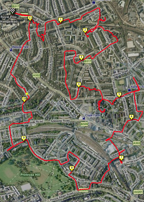
There are two styles – Street-O and Pseud-O.

Street-O

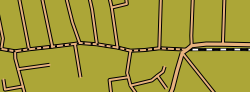
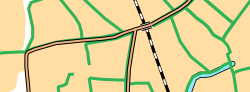
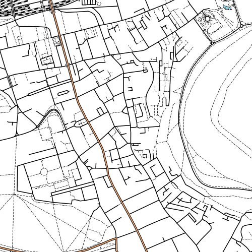
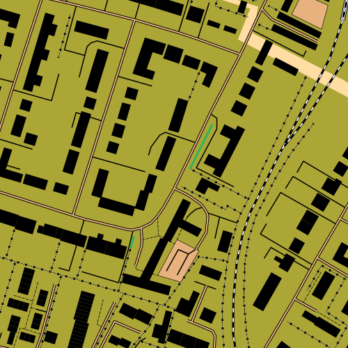
This attempts to recreate the “minimalistic” feel of street-O maps, as used for informal street events in London by the central clubs SLOW and LOK, and in other areas around the UK. Only roads, tracks, paths, rivers/lakes and railways are shown, the maps are high-contrast (black on white) and have little colour. The few colours that are on the map – for major roads and water features – are the “official” ISOM standard colours for these features.

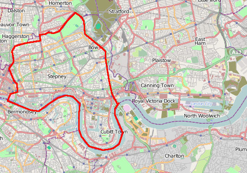
OpenStreetMap data has been used for one street-O before – my Bow race in September, although here the data was pulled into Quantum GIS and a vector-based PDF was produced, allowing maps to be printed at high resolution.
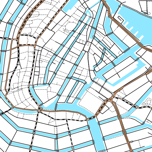
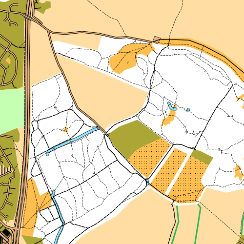
oom4

Pseud-O

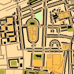
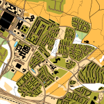
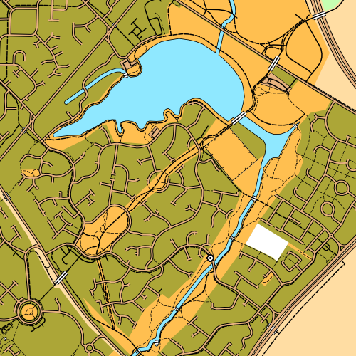
This is a less standard but richer map. It uses many more features in the OSM data, where they correspond to regular orienteering features. OSM data, for ~99.999% of areas, is not detailed enough to correspond to that on an ISOM map, but it might be sufficient for basic urban orienteering events in a few places, or the odd trail challenge. As the OpenStreetMap dataset continues to be added to and enhanced by its contributors, so the orienteering map will increase in complexity and accuracy. Again, the colours are as officially defined in ISOM. For now, it’s fun to look at the whole of the UK with the ISOM look-and-feel, but let’s not run any serious events with the map! (More on ISOM orienteering maps and OSM.)

oom2

The postcode finder uses the c. 70000 postcodes supplied by NPEMap (with contributions from FreeThePostCode and the postbox locator project) so should get you to within a mile or two of where you want to be, in urban areas.

Explore the map and let me know about any big problems with the cartography or functionality via the comments here. I’m not interested in missing data complaints for an area though – OSM is a project produced by the efforts of volunteers, so if your area is blank, it’s because there isn’t an interested local. So go and map the area yourself, and add it to OpenStreetMap so the whole world benefits (and let me know so I pull in the updated dataset!)

oom3

More information about how the map is made is here.

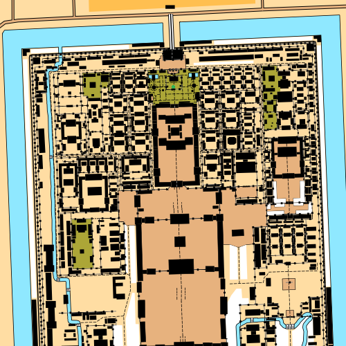
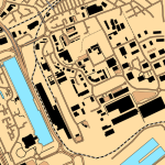
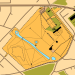
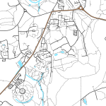
Top: Good to see the efforts of the Milton Keynes mapping party I organised in May make it to an orienteering map. Upper Middle: Edinburgh’s Old Town. Lower Middle: Shotover Wood, near Oxford. Bottom: Great detail in Putney, thanks to an enthusiastic local contributor in the area.

Categories
Orienteering

Testing Video Embedding

I’ve just set up the ability to embed videos in the blogs running off my department’s blog server, so here’s a couple of videos to test it works.

Vimeo example video:

Interland 2009 from Ultimate Orienteering on Vimeo.

Youtube example video:

Categories
Orienteering

East End Orienteering

As mentioned previously, I’m hoping there’s going to be some orienteering races put on in London’s East End over the next few years – I might organise a few. The first is likely to be a street race in April.

One interesting question though – where exactly is the East End? How big is it, how far east (and west, north and south) does it extend? Wikipedia has an article on it but simply says it’s east of the City of London and north of the River Thames.

Here’s where I think it is:
StaticMap

What about Eastenders?
eastenders

The Hitchhiker’s Guide to the Galaxy has a suprisingly succinct definition:
h2g2

Here’s an old map showing from where you can hear the Bow Bells (from St Mary-Le-Bow in the City, not in Bow) ringing, presumably assuming a prevailing south-westerly wind carrying the sound north-eastwards from the City. Why is this interesting? Well, the traditional definition of a Cockney (i.e a Eastender) is someone who was born within earshot of the bells.


Original source http://home.clara.net/praveen/bowmapjpg.jpg is no longer available.

Modern traffic noise, even at night, means that the bells would no longer be audible at such a range.

Categories
Orienteering

South Hampstead Street-O

My route from last night’s Street-O race in South Hampstead.

Screen shot 2009-12-04 at 02.15.40