Categories
Olympic Park

Olympic Stadium – It’s a Wrap

Look what’s appeared on the north side of the Olympic Stadium in east London:

A section of what looks like wrap has appeared on the outside of a small part of the building. On the top left, in tiny writing in the jagged London 2012 font, it reads “Be Safe Home Safe” which is the current safety slogan on site. An image of what the stadium might look like once the wrap goes all the way around can be found on the portacabins for Team Stadium:

Other things I noticed today are that a lot of the hoardings surrounding the lower part of the stadium perimeter have disappeared, revealing part of the huge concrete plaza that will be in front of the stadium, and also allowing a glimpse inside, where rows and rows of white seats can be seen.

The Orbit is also gradually increasing in height, although not as quickly as before. A big line of red pieces, looking like giant , lie beside the structure.

You can see all the photographs I took this morning.

Categories
Olympic Park

The Changing London Olympic Park – 2006 to 2010

Screenshot of the website.

Inspired by Andrew Kesper’s ABC before/after photos of the Japan tsunami destruction, I have created a “scrubber” photo of the London Olympic construction site in the east of the capital, using the imagery available in Google Earth. The aerial photography is copyright Google and Bluesky. You can the see the original imagery in Google Earth by using the program’s timeline slider, there are some other years also available there, even one from December 1945.

Move your mouse over the picture, to swipe between the 2006 and 2010 imagery. [Now offline]

I’m using JQuery to handle the mouse positioning. Creating such a graphic is quite straightforward. There’s only about 10 lines of JavaScript code involved, plus some CSS styling. It even sort of works on the iPhone – tap once to reposition the dividing line. All credit to Andrew and ABC for the idea.

Categories
Olympic Park

Will this be Britain’s Most Secure Road?

I spotted this sign attached to the edge of the Eton Manor site, on the Eastway just north of the London 2012 construction site, last weekend:

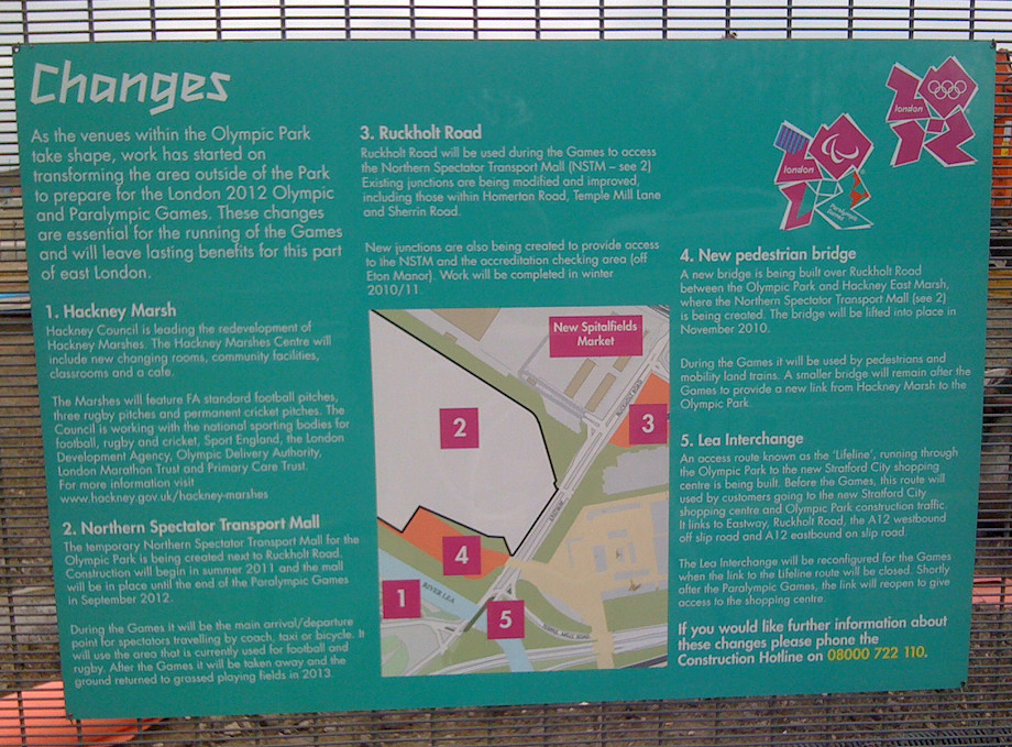
Lots of interesting information on here. As well as the “Hackney Marshes Centre” (aka South Marshes Community Hub) and the “Northern Spectator Transport Mall” (aka East Marsh) which I’ve covered before, there is mention of a new road – referred to as the “Lifeline” here, it is more specifically called the “Northern Retail Lifeline” in the Olympic Delivery Authority (ODA) planning documents I’ve dug up.

The Westfield Stratford City development was planned before the Olympics were awarded to London, and it always intended to open in 2011. As it stands, the triangular site is surrounded on two out of three sides by the huge Olympic construction site, and so would have been rather difficult to access upon opening, except from Stratford, until the Olympic security fences start to come down in 2013. To alleviate this poor access, the ODA was apparently obliged to provide a special access route from Walthamstow, Hackney and the A12 to the north, through the Olympic building site, to Stratford City.

The planning documents reveal some interesting information about the road.

Firstly, and most disappointingly, should I want to cycle over to Waitrose (this will not be the Stratford I know!) from Hackney Wick, I won’t be able to.

“NRL will only be for motor vehicles no larger than ‘4×4/SUV’ type vehicles. Furthermore, neither public transport nor pedestrians nor cyclists will be permitted”

Boo!

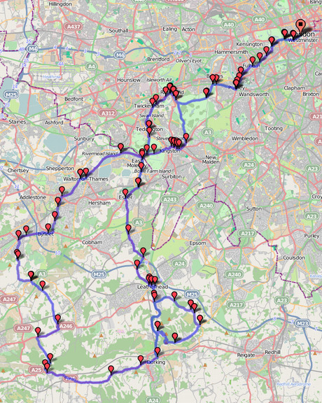
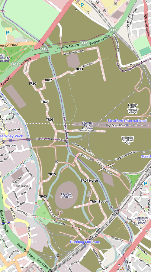
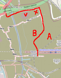
The road seems to start at the A12 junction, swinging sharply east and passing north of the newly completed Velodrome (V) and BMX track (X), before heading down to the Athlete’s Village (A). It then goes around the village boundary in an anticlockwise direction, passing the fluted white Basketball Arena (B) before heading straight down to join the Stratford City boundary. You can see much of the route in the plan here. I’ve drawn what I think is the whole route, on an OpenStreetMap on the right – also contains data CC-By-SA OpenStreetMap contributors.

At the north end of the road,

“The northern vehicle screening area, adjacent to the A12 Lea Interchange, will stop and check traffic” … “The security guard will indicate whether a vehicle has been selected by hand held signals and a display board.”

This sounds fairly involved, but in fact the security arrangements for Canary Wharf are rather similar and this hasn’t stopped it being rather popular.

There might be some bad news if you are disabled, as:

“The vehicle height restrictors will match the Stratford City car park restrictors of 2.2m. However, Stratford City allow 2.7m high vehicles on the ground floor for high sided disabled vehicles so these will not be able to exit or enter via the NRL.”

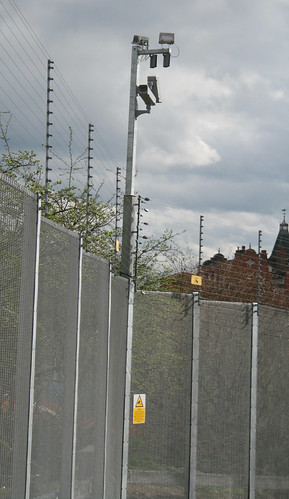
Once you are on the Lifeline road, don’t think about stopping for some nice close-up photos of the Velodrome, as this is not designed to be a welcoming road. The fence on either the side of the road:

“will be 3.6m high and does not include the standard power topping implemented on the Outer Perimeter Fence (OPF) across the majority of the Park.”

The “power topping” is a slightly euphemistic way of describing electric fences. Presumably the security checkpoints make the Lifeline a “partially secure zone” which is why they are deemed not required here.

Also:

“CCTV cameras will be mounted on extended fence posts every 40m at a height of 5.8m”

The road will open with Stratford City this autumn and then close again in June next year for the “Games lock down”, before presumably reopening while the rest of the park get transformed into post-Games mode.

The entrance to the Lifeline appears to be under intense construction at the moment – the Eastway road is a bit of a mess. East-bound cyclists have to walk a considerable distance along the pedestrian footpath. The Eastway is an important cycle link between Hackney and Leyton. It is set for improvement too though – I spotted another application for a dedicated cycle and footbridge further along to the east. The west-bound route is also a real mess currently, with a lot of weaving around various bits of construction – or braving it on the dual-carriageway.

Some more interesting planning documents I found are this one which maps out the internal roads of the Olympic Park, and lists their names – Stadium Gardens, Handball Approach etc. Also, this letter outlines the plans for the park area west of the velodrome – the “North West Parklands”. Originally this was going to be a dramatic double crossing of the river by the cycle track – part of the “Velo Park”, but now, with the track being somewhat downgraded and placed east of the Velodrome, this is going to be more traditional open space, an “interim landscape zone” with presumably the eventual intent to build. There is a nice map here.

[Update: The somewhat depressing (in that apparently nothing good is ever done on site) Games Monitor blog spotted this a while back.]

Categories
Olympic Park

East Marsh’s Days are Numbered

It looks like the East Marsh, part of Hackney Marshes, the world’s biggest complex of football pitches, is about to disappear under concrete, to form a coach park for the London Olympics. I was hoping it was never going to happen, as a quarter of the marsh is already fenced off, and that construction site hadn’t grown in size for a while, but it does look like it will be expanding right across the field from 22 May. The fields should be restored to grassland and football pitches a couple of years after the games. Fingers crossed.

(Although personally I think it would make a great site for a big housing development. There is very little housing in the immediate area around East Marsh, apart from a tiny terrace of travellers’ homes.)

In the Google Maps aerial imagery reproduced below, you can see the East Marsh, with a quarter already taken out by the Olympics construction site (the photo is from last June.) The now-completed velodrome is on the bottom right, with a bridge across the A12. Another bridge, “L01”, is now in place across the next road north, linking to the existing construction area on the East Marsh – you can see the red support trusses in place in the photo, built in advance of the bridge lift. The old “Cow Bridge” links the East Marsh to the rest of the Hackney Marshes, while a new set of changing rooms and cafe is under construction to the south-west of this bridge – the facility is also now completed and open. There are plans, I believe, for a new footbridge, to cross the channel and provide a more direct link from the changing rooms to the East Marsh, once it is restored.

To the top-right of the marsh, is the relocated Spitalfields Market. Why the plaza here couldn’t have been used instead for the coach park, for the four weeks of the Olympics and Paralympics, I do not know.

Imagery ©2011 Google, DigitalGlobe, Infoterra Ltd & Bluesky, GeoEye, Getmapping plc, Bluesky, The GeoInformation Group.

Categories
London Olympic Park

New Aerial Photos of Central London in Google Maps

Google Maps has today updated its aerial imagery for central London. The new imagery appears to be from sometime late last summer, and reveals the many new buildings and features that have appeared in the capital recently.

Above is the Olympic Stadium (with the triangular lighting gantries casting shadows into the bowl) and the partially complete Aquatic Centre. The high-capacity bridges linking to the stadium are in place. Below shows the coach park for the Olympics intruding into East Marsh, part of the famous Hackney Marshes. I’ve also included some pictures of the curvy new Walbrook building, on Cannon Street, which is squeezed around a tiny churchyard, and the new Shoredich High Street Station, with surrounding brownfield land.

…and here’s a plane in a very central location.

Categories
London Olympic Park

Will you be buying tickets for the London Olympics?

So are you coming to the greatest show on earth in London next summer? Or are you making a point of staying away? Perhaps even going to a rival sporting event?

Answer my one-question survey below, and enter the first bit of your postcode, and a map will be drawn automatically, showing how the country’s enthusiam for tickets for the games varies!

Categories
Olympic Park

Orbit Rising – An Extrusion from the Ground

ArchelorMittal Orbit

The ArchelorMittal Orbit, a giant sculpture designed by Anish Kapoor and sited right next to the London 2012 Olympic Stadium, is starting to appear from the ground, looking, at the moment, like a giant-sized playground “mesh”. I like the momentary juxtaposition of the bright yellow cranes and bright red base-struture. The Athletes’ Village is behind the Orbit in these pictures, which I took from the View Tube. The Aquatic Centre, with its bizarre high temporary seating gantries, is just off to the right.

See the photo album on Flickr.

ArchelorMittal Orbit

Categories
Cycling Leisure Olympic Park

London Olympics – Cycling Road Race Route

The final route for the cycling road race, at next year’s London Olympics, has been published today. Unfortunately it’s only available as a PDF, so I’ve plotted it on BikeRouteToaster, you can see it here.

Here’s a download as a GPX file or as a KML file (for Google Earth.)

I like the inclusion of both Richmond Park and Bushy Park in the outward route. I normally try to include both when doing a day-cycle out to the west, recently they featured in routes to Windsor and to Oxford. Box Hill’s Zig Zag Road is a classic hair-pin climb. The cyclists will go down Coombe Hill – I know this hill well. It’s a pretty evil hill to go up and I would imagine it’s a lot of fun going down. Indeed it was the biggest hill I went up on the last day of my Land’s End to London cycle last year, and the hill that nearly broke my cycling partner, Paul, during training for that trip. However we both managed Box Hill just fine an hour later.

My route only goes around the Box Hill loop twice, whereas the Women’s Race goes around three times and the men cycle around it nine times! This is why my route is only 142km with 900m of climb, while they have considerably further and a lot more climb! However I think 142km is manageable for me as a nice bike ride this summer.

Here’s the profile:

The photo at the top shows part of the KML file of the route in Google Earth. The middle pic is using OpenStreetMap as a background map.

Categories
London Olympic Park

Everyone’s Putting London 2012 on the Map

The Geographers’ AZ Map Company, makers of those iconic London atlases, got quite a bit of publicity earlier this week for putting out an extract of their latest map, showing the complete Olympic venues and Olympic Park layout, despite the event still being eighteen months away. Indeed the map will only be accurate during summer 2012 itself, as most of the venues will then be dismantled, and the park re-landscaped, after the six weeks of Olympic and Paralympic events.

They weren’t the first in getting their public map up-to-date though – I added in simplified shapes of the key arenas in the Olympic Park to OpenStreetMap, based on first hand observation from the park perimeter fence and the bus tours, several months ago. The Olympic Stadium is very roughly drawn, in particular. However, the Bing Maps announcement, also this week, of donations of its aerial imagery to OpenStreetMap, may mean I can update the shape to match the “bowl” that is visible in the circa 2008 photography available of the park.

The Ordnance Survey also has updated its Landranger map – the new version with the venues appearing on the OS’s own Getamap online survey, but not on the scans used by Bing maps.

Also, the OS has today made available a PDF of a special map – Engineering the Olympic Park – made for the Institute of Civil Engineers (more details). It’s a shame I only heard about this now, as a paper copy would have been a (map-)collector’s item, and they were handing them out at the View Tube which is close by where I live. Oh well.

The OS map’s photo of “Before 2005” is slightly cheeky, implying the entire site was full of rubbish bins, pylons and abandoned caravans. Certainly parts of the site were derelict, but other parts were quite pleasant. As a more thorough representation, Diamond Geezer did a careful survey of the whole area before the fences went up in 2007/8. Actually, having looking at the photos there again now, the dereliction probably did outweigh the beauty.

(As an aside, some of the other details on the A-Z extract are questionable, even without considering representation of buildings that don’t yet exist and might not end up entirely like their planned form. There appears to be a giant “playground” in Victoria Park, in the left-most part of the extract, which is just another part of the park’s grassland area in real life. They’ve also got the old Hackney Marshes sports pavilion, shown as “Pav” on the top-left of the extract, even though this was demolished last year and replaced by a new, larger building, further to the west, which opened last weekend. It seems that in their (quite understandable) rush to capitalise on the Olympic buzz, they’ve forgotten about the local community changes surrounding the park. Hmm, now where have I heard of that before?)

Categories
Olympic Park OpenStreetMap

Mapping the London Olympics

Here’s what the Olympic Park in East London currently looks like on OpenStreetMap, following my recent tour and some other visual guestimating from outside the boundary fence:

The brown areas shows the construction sites, most of which are for the Olympic Park, apart from the eastern area which is the Stratford City development and the southernmost area which is the Crossrail Pudding Mill Lane construction.

The main stadium is a rather unsteady oval, the media centre is the not-quite-rectangular building in the left-hand corner, the velodrome is the hexagon, and the aquatic centre is the diamond. These are all simplified shapes based on what I see, rather than any official plans. There aren’t any buildings yet for the athletes’ village (the fifth of the Big 5 permanent venues) or the Westfield Stratford City mega-development, just POIs. The roads are rather incomplete – although unlike the main venues, these might not be permanent. It’s about as complete as I can get it without privileged access to the site (unlikely) or tracing from detailed aerial or elevated imagery. There’s lots of such imagery out there – the official London 2012 blog has published quite a lot recently, as have some media.

So this is a plea to anyone owning such imagery – if they don’t mind it being used for OpenStreetMap data (i.e. happy to licence it under a Creative Commons Attribution licence) to let the OSM community use it for such purposes, so this high-profile site looks great and up-to-date on the map that everyone can use.

…or I could just wait until the park opens in two years time.