Categories
Leisure

The Loire

Back from a proper holiday – not one involving running around forests or walking up hills, rather one visiting castles and vineyards, and even a bit of fine dining. It was a trip to the Loire with a friend, Nick. We got the Eurostar from London and then the TGV from Paris to Tours. The following day we picked up a hire car and gradually headed west, via Loches, Decartes (renamed after its most famous resident), Villandry, Bethenay, Chinon, Saumur and Behuard, to Angers. The wine caves at Saumur were a particular highlight, although we did supplement our wine haul here with more at the Le Clerc supermarket at Brissac-Quince. Loches was also a particularly beautiful place!

Some pictures on Flickr:

Categories
Leisure

Munroist in Progress

I’m currently in Scotland for the extended Easter/Royal Wedding/Bank Holiday break, and have been taking advantage of the current unusually fine weather – and a special cheap train fares deal – to make multiple excusions up into the Highlands to indulge in a spot of Munroing – climbing a few of the 283-odd peak in Scotland that are over 3000 feet and so become “Munros”. So far I’ve been twice up on the West Highland Line to Loch Lomond and to Tulloch, and tomorrow, if all goes to plan, I’ll be up in Glen Tilt tomorrow.

If you are ever travelling on the West Highland Line, which by some measures is the world’s most scenic railway, I recommend sitting on the left going up – or the right going back down. With the exception of the Loch Lomond section, the views are generally finer on that side. Particular highlights are the elevated views over Loch Long, Loch Lomond, Loch Tulla and Loch Trieg, and to several of the many mountains – The Cobbler, Ben Lui and Beinn Dorain to name but three. The Cobbler is too low to be a Munro itself, but its three thrilling summits (one requiring a scramble, one requiring an exposed move and one perched above overhanging cliffs) make it far finer than its surrounding Munros. It is one of the classic mountains of Scotland.

Obviously the Glenfinnan Viaduct (hello Harry Potter) and the rest of the section that continues to Mallaig is also incredibly scenic, but I haven’t made it that far this time, partly because there aren’t many Munros that far along and partly because the train takes over five hours to get there from Edinburgh…

The photograph above, which has come out surprisingly well on my geriatric 3-year-old iPhone, was taken on Wednesday and is looking south over to Loch Trieg, from the summit of Beinn Teallach, a mountain which has the dubious distinction of being the lowest of all the Munros.

Categories
Leisure

Olympic Update

I went for another circumnavigation of the Olympic site at the weekend. I was expecting to get some nice pictures as the sun came out just before sunset, with the air very clear as it had been raining early. For some reason though I struggled to take anything interesting in the park itself. The sunset itself was amazing though, and I noticed for the first time that the Gherkin is lined up perfectly with the Hertford Cut:

The Orbit continues to rise, it is now nine “tiers” high. The horizontal links will eventually I think be hidden behind a wrap, at least for the lower levels. It is interesting that there is still no scaffolding around the sculpture itself, with everything so far lifted in by crane and then bolted on by workers who are using the structure itself as the scaffolding. This presumably will not be possible to do once it gets much higher and starts to loop down and around:

It was also nice to see the salmon-pink Formans factory, itself a salmon processing plant, bathed in a salmon-pink sunset:

You can see all of the pictures in a Flickr gallery, including the previous Orbit ones.

Categories
Cycling Leisure Olympic Park

London Olympics – Cycling Road Race Route

The final route for the cycling road race, at next year’s London Olympics, has been published today. Unfortunately it’s only available as a PDF, so I’ve plotted it on BikeRouteToaster, you can see it here.

Here’s a download as a GPX file or as a KML file (for Google Earth.)

I like the inclusion of both Richmond Park and Bushy Park in the outward route. I normally try to include both when doing a day-cycle out to the west, recently they featured in routes to Windsor and to Oxford. Box Hill’s Zig Zag Road is a classic hair-pin climb. The cyclists will go down Coombe Hill – I know this hill well. It’s a pretty evil hill to go up and I would imagine it’s a lot of fun going down. Indeed it was the biggest hill I went up on the last day of my Land’s End to London cycle last year, and the hill that nearly broke my cycling partner, Paul, during training for that trip. However we both managed Box Hill just fine an hour later.

My route only goes around the Box Hill loop twice, whereas the Women’s Race goes around three times and the men cycle around it nine times! This is why my route is only 142km with 900m of climb, while they have considerably further and a lot more climb! However I think 142km is manageable for me as a nice bike ride this summer.

Here’s the profile:

The photo at the top shows part of the KML file of the route in Google Earth. The middle pic is using OpenStreetMap as a background map.

Categories
Leisure

London 2012 Training Guides

Now this is interesting – I spotted on Amazon these London 2012 Olympic Games training guides, which are coming out at the beginning of March. There are four – Track, Field, Cycling and Swimming. I’m not sure quite who they are aimed at – not the pros I presume, but are they trying to cater for both complete beginners and club-level athletes (the blurb suggests so.) I’m also not sure about all the other Olympic sports that don’t fit into the four categories, e.g. Rowing and Sailing. I think we are quite good at those!

There’s also an “The Official Countdown to the London 2012 Games” which is launching at the same time. Could be interesting.

The London 2012 “brand” (i.e. jagged lines) is starting to grow on me, it has to be said. No circles in sight!

Categories
Leisure OpenStreetMap

Nike Grid is Back

Nike’s alternative reality game/metrogaine/street-o – Nike Grid – is coming back to the streets of London. This time it’s over two weeks rather than just a weekend, and involves an element of teamplay – you can join a team based on your London quadrant (N, E, S or W) or university, or an adhoc one.

Of note, the map in the player pack is a rather nice (I think) restyled silver-and-black version of the green-and-black fold-out maps used in the original game. The source data is OpenStreetMap and the cartography reminds me somewhat of 8-Bit City – it’s not particularly useful for precision navigation, but is a nice example of Boing-Boing cartography, to borrow an expression from a talk at the recent Society of Cartographers conference. Oh, and they have credited OpenStreetMap contributors this time – yay!

Categories
Leisure

Long Distance Routing with the Garmin Forerunner 305

I’ve just cycled from Land’s End to London, taking a meandering route and covering 1012km (630 miles) over the course of 10 days. And I did it without any maps. Instead, I used the “Courses” functionality in the Garmin Forerunner 305 sports GPS unit.

The courses were TCX files, generated at BikeRouteToaster using the routing supplied by Google Maps and Cloudmade (OpenStreetMap data) – I alternated between the two depending on which showed the best looking cycle routes or most complete coverage of country lanes. Google’s road coverage is more complete but it’s API can (currently) only route journeys based on rules optimised for cars. OpenStreetMap still has big gaps in coverage in parts but is pretty good and showing dedicated cycle paths, in particular the flat (a luxury in Devon/Cornwall!) “rail trails”.


The first day’s route, as viewed in BikeRouteToaster

The TCX files are XML and are made up of two parts – the route itself, which is represented on the Forerunner unit itself as a meandering line, and turn indicators, which are derived from the data and in most cases are right – a spurious “straight on” indicator often appears when the country lane changes name, but most junctions are detected, apart from where the main road typically turns and the minor road carries straight on. This does result normally in a couple of unplanned detours, particularly for very shallow junctions where both the road and the junction turn in similar directions, where the route line does not help, but in general it means you can do a complete cycle without having to get a map (or smartphone) out at every junction.

One problem is restricted memory in the Forerunner 305, and that the use of this limited space doesn’t necessarily correspond the size of the data in the TCX files. For example, the turn directions took up around 10% of the space of the route lines in my TCX file, but appeared to take up double the space of the route lines on the device. By removing turn directions from the TCX files, reducing their files sizes by only 10%, I was able to store more than double the number of route lines.


The first day’s route in Garmin Training Center, before and after the turn directions were removed.

Older versions of the Garmin Training Center (sic) application, used to upload the TCX files, would fail silently, without loading all the files, when the memory limit was reached, and the current web-based uploader tool also gives an unobvious error message when the device runs out of space on uploading. However, the latest version of Garmin Training Center includes a pre-processing tool that examines the TCX files and only lets you upload files which collectively don’t exceed the limit – using checkboxes a useful “full bar” indicators. With this, I was able to see what files I could include, and that by removing the (relatively small sized) turn indicators, I was able to load in almost all 10 days worth of files.


The Garmin Training Center upload screen, before and after the removal of the turn-based directions, showing the difference it makes to the capacity used on the device (A striking difference, given that the turn-based directions only take up ~10% of the original TCX XML file.)

Categories
Leisure Notes Orienteering

Summer Plans

What I’m planning on doing this summer:

3 June pm LOK Park Race Grovelands Park 5km
5 June parkrun Hackney Marshes 5km
8 June pm SLOW Park Race Battersea Park 5km
11-21 June A wedding/Lakes/Knoydart trip
22 June pm SLOW Trail Challenge Ham 10km
26-27 June A stag
29 June pm SLOW Park Race Tooting Bec Common 5km
3 July parkrun (maybe) Hackney Marshes 5km
3 July North Downs Relay North Downs 10km
4 July LOK London Interclub Addington Hills 7km
7-15 July Sweden training tour
17 July parkrun Hackney Marshes 5km
18 July MV London Interclub Ashtead 7km
20 July pm SLOW Park Race Bishop’s Park 5km
21 July pm DFOK local event Shooters Hill 5km
22 – 31 July Land’s End-London cycling trip
4 August pm DFOK local event Lesnes Abbey 5km
7 August parkrun Hackney Marshes 5km
8 August SAX Trail Challenge Sevenoaks 21.1km
10 August pm SLOW Trail Challenge Richmond Park 10km
11 August pm DFOK local event Bostall Heath 5km
13-15 August Purple Thistle orienteering event
16-22 August Hillwalking/Edinburgh Fringe
28 August parkrun Hackney Marshes 5km
30 August Urban Race Didcot 7km
4 Sept Urban Race Sheffield 7km
5 Sept Urban Race Lincoln 7km
9 Sept pm DFOK local event Jubilee Park 5km
11 Sept Two2Go marathon Lea Valley 42.2km
18 Sept Urban Race City of London 10km
19 Sept LOK local event Hampstead Heath 7km
25 Sept Urban Race St Andrews 7km
26 Sept District event Tentsmuir 10km
2 Oct parkrun Hackney Marshes 5km
3 Oct Urban Race Warwick 7km
Categories
Leisure

Hackney Marshes parkrun

There’s going to be more than just football going on in Hackney Marshes on Saturday mornings in the future – the parkrun series of 5km running races is coming to Hackney and the inaugural is this coming Saturday at 9am – and then every Saturday at 9am. Same time, same place, every week. Simple.

The course is most suited to people who like off-road as well as on-road running. The first 2km is on a tarmac’d track, the next 2km is on grass around the East Marsh, with a great view of the emerging Velodrome in the Olympic Park, and the southern edge of the main Marshes, and the final km is on a tarmac’d track beside the Lee Navigation Canal.

I’ll be helping out at the finish, rather than running it, as my legs won’t quite have recovered from last weekend’s marathon. Once I am back into running, the event should have excellent PB potential (if the grass doesn’t slow things down too much) as it is a completely flat course. Much as I like Finsbury parkrun, the hills do add a good 45 seconds to my run each time. I expect I will alternate between the two, though, as each has its charms.

If you are in south London, Crystal Palace is also starting a parkrun this weekend. Ironically, it’s now pretty easy to get to from Hackney, thanks to the new Overground service that runs from Dalston.

Categories
Leisure Olympic Park

Inside the Olympic Park

A couple of weeks ago, I went on one of the daily tours of the Olympic Park in London, organised by the Olympic Delivery Authority. Anyone can now go on these tours, rather than just local residents, but you do need to book a couple of months in advance. This summer is probably the best time to take the tour, as the “big build” of all the main venues is in its busiest phase. In theory, everything should be built by next summer, with a clear year to then test the venues.

The day I chose ended up being a grey and cold Sunday – not great for taking photographs – but it was still very worthwhile touring the site. The tours are on a single-decker bus, with a Blue Badge guide giving an interesting narration. After being picked up from Stratford and given a fold-out map of the site, we were then driven right around the A12 to Hackney Wick and the northern plaza entrance, where the bus was subjected to an elaborate sniffer-dog search, presumably just for show as the bus had already done several other tours on the day – and because we had no such check on re-entering the site from the southern plaza. It was a good opportunity for a safety and security briefing, though. (The northern plaza is where building materials are generally delivered – workers arrive several miles away at the southern plaza, generally from a DLR station there.)

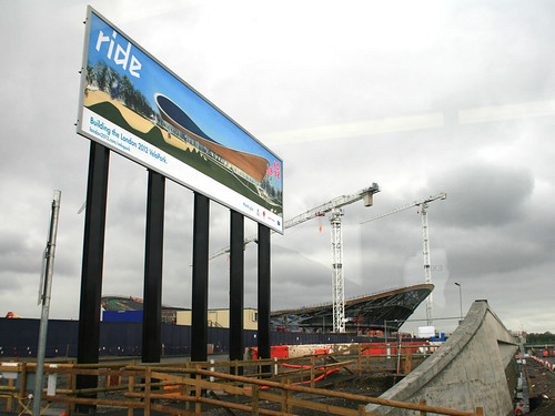
First up was the Velodrome, aka the Pringle because of the distinctive shape of its roof. It’s close to the northern edge of the site and is very visible from the A12. Beside it is a billboard with an illustration of how it will look when complete:

Velodrome - Soon and Now (7628)

The Velodrome is one of the “Big 5” construction projects for the permanent buildings, along with the stadium, aquatic centre, athletes’ village and broadcast centre.

We then headed south, passing the basketball venue, a temporary building which has appeared from nowhere in just one month – already the “crazy paving” white plastic cladding is going on:

Basketball Arena (7650)

The Olympic Park isn’t the only building project going on in the area – along with Crossrail, the other big construction site is for the Stratford City Westfield development, which is more advanced and is due to open next year. A giant pedestrian bridge is being built between the two, and there is also a link road – the “Western Access”. The boundary between the two, with construction in all directions, is marked by a blue box:

Boundary between the Olympic Park and Stratford City (7654)

The stadium is visible from the northern section we were in, but the main construction road was blocked due to some temporary works on one of the many bridges bisecting the numerous rivers, canals and channels in the site:

The Way to the Stadium is Closed (7660)

So we headed back onto the A12, around to Stratford, and back into the site through the southern plaza, an electronic sign there showing an impressive safety record:

Safety Record (7671)

Firstly, we went up close to the stadium itself, the basic shape of which is complete. The black section is the “temporary” section, although it might be around for longer than planned after the Olympics depending on what the stadium gets used for:

Olympic Stadium (7689)

Olympic Road Sign! (7702)
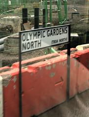
We then went round to the eastern part of the site, where the aquatic centre is. On the way I spotted many of the road signs which have appeared on the site – as well as Olympic Gardens North and South, and Stadium Crescent East and West, I had earlier spotted Handball Way, Handball Approach, Velo Drive, Stadium Aquatics Link, Plaza Approach, Soc Highway, Waterden Road Works South, Wetlands Avenue East, H08 Diversion and the intriguingly named Norman Corner.

All of these signs are mounted on “permanent” metal signposts and look like regular street-name signs. Rather than also showing the first part of the postcode, and is traditionally done for London street-name signs, these signs include reference numbers starting with “TR”. (Trunk road?) I’ve added all the names I spotted to OpenStreetMap.

The aquatic centre is being built by first placing the roof on its supports, and then filling in the space beneath it. The dramatic Zaha Hadid wave shape of the roof looks brilliant up close:

Aquatic Centre - Side View (7724)

From one angle, it appears to hang over one of the water channels:

Aquatic Centre beside the River Lea (7719)

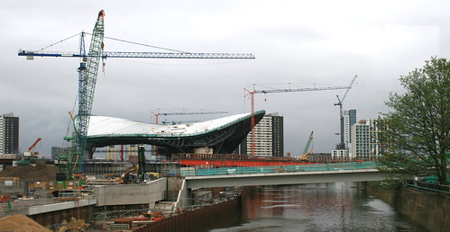
From another, it looks like a futuristic space ship:

Aquatic Centre - End-on View (7716)

I headed back home along the Greenway, a raised route through the site, open to the public and the best way to see the site if you aren’t on the bus tour. Along the way, I noticed the mysterious concrete posts, that appeared a few months ago, have finally revealed their purpose – they are rather fancy signposts:

Greenway Sign (7738)

You can see more pictures I took in my Flickr album.