Categories
Orienteering Orienteering Events Log

Scottish 6 Days Part 2: Day 6 & Trail-O

The final day of Moray 2013 looked, on paper, quite similar to the others – around 9km, like the previous 5 days. However it was quite different in feel, with the combination of climb (495m) and both technical and physical sections of the course, meaning most people, including me, took ~20% longer than on their other days.

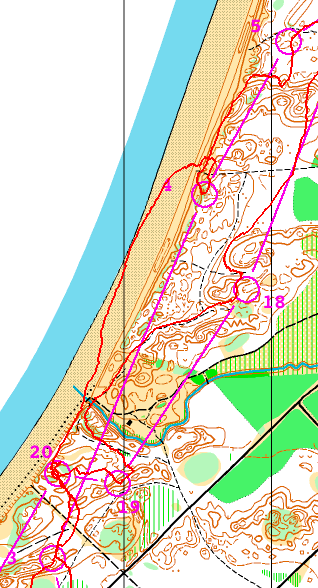
The first part of the course was a control pick, with many short legs, in technical and hilly wooded moraine terrain. The forest looked very pleasant in the sunlight, and the controls came up fast:

s6d6part1

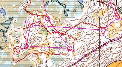
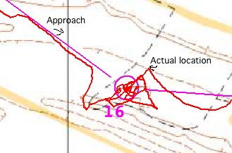
The second part, however was physically tougher. After crossing the A939 road, the undergrowth levels increased, and a couple of long legs proved to be a good test of navigation. A vaguely mapped, low-visibility and marshy area near the end was a nasty suprise, with four controls for M21L proving to be hard to find:

s6d6part2

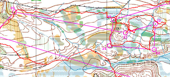
(The elites ran through this area without any controls in it, although to be fair they did have a 17.1km course.)

For the last few legs of my 9.3km one, I ran out of energy, for the first time in the week, and ended up walking up the last hill. I expected a bad result, but it turns out everyone else found it tough too, and I finished in the top third today and overall.

A few days before, during the “rest day”, I tried out the Trail-O course in Culbin. My only previous Trail-O was in Portugal, where I didn’t do particularly well, partly because I overthought the planning. Trail-O is perhaps the most pedantic form of orienteering, which much though and toing-and-froing needed to work out exactly which of the controls on the terrain are the mapped ones. In the toughest control sets, there were typically only one metre between controls, and Trail-O participants don’t even get to visit the controls themselves, being restricted to the path network. Still, it was a good challenge, and I again finished in a lower position than I was hoping, with 17 of the 23 controls correct – the winner got 21, so maybe if I’d spent a little longer, or conversely a little less time to overthink it… One of my 6 mistakes was due to not understanding the difference between the viewing and punching point, resulting interestingly in a parallax error. Fellow SLOWie Michael Balling unexpectedly won the entire Trail-O competition, beating the British Team, even though he jogged rather than walked around the course, getting around in the fastest time even though there is no bonus for that. There is a lesson there!

Over an enjoyable Scottish 6 Days, on six great areas, and I look forward to 2015’s event which will be not far away, and combined with the World Championships.

Categories
Orienteering Orienteering Events Log

The Scottish 6 Days at Moray

I’m just back from six days of top quality orienteering races in Moray, north-east Scotland. As ever, the days were very varied, with three days of forested dunes, two hilly inland map, and one flat (but still intricate) forest that I once trained in when in the Army section of the CCF at school! The Scottish weather also lived up to its four-seasons-in-a-day reputation, with two days of pouring rain, two days of bright sunshine, and everything in between. I was running M21L, as I didn’t think I would make it around the M21E 17km+ classic on Day 6, and because I was aiming for the top half of the results table each day, rather than inevitably hanging around the bottom 20% as would happen on the Elite class.

Day 1 was at Lossie forest, a classic sand-dune area which I didn’t have great memories of – mainly because I was smaller when I last ran it and I remember the sand dunes being steep and dense – walking rather than running required in order to avoid getting quickly lost. Sadly, it is not quite the same as it was these days – a new track running right through the intricate part meant that the technical level has greatly dropped, and the course design (perhaps necessitated by the sheer number of people, around 3500, at the Scottish 6 Days event) meant that many of the legs were a procession between controls, with people and/or tracked routes pointing the way between controls.

I had a very poor start, heading off 90 degrees in the wrong direction (following the train…) and later on I made my biggest mistake on this day, although this was primarily due to a control being placed on a feature mapped in the wrong location on the map. Discussion afterwards indicated that plenty of others also were delayed here, but unfortunately I responded particularly poorly to the map’s mistake, looking for an (absent) flag rather than the misplaced feature, which was fairly easy to see, if 80 metres NE of where it should have been:

s6d1mistake

Day 2 was the aformentioned Army area – Carse of Arsidier. I had a cleaner run here, with just the few small mistakes which were a hallmark throughout the week of me not staying in enough contact with the map as I should be. Day 3 was back onto dunes, at Culbin, although it was the western part of the map rather than the more familiar main section which we visited during the following rest day for a Trail-O. Day 3’s result was my worst of the week, although I think this was primarily due to having an early run on that day, with little tracking to follow. There is a presumed correlation between the time people run on a large forested (i.e. trackable) event and how well they do. Day 4 was the first hilly day, at Loch of Boath. Unfortunately it was also the wettest day. It was also potentially my best day, with a pretty clean run, until near the end when I started to think “I’m on for a good one here” and promptly made two medium-sized mistakes in a row.

Day 5 was back to the dune areas and Roseisle. This was always going to be my favourite area of the week and so it proved, with undergrowth-free pine forest (with a lovely natural pine smell in places!) providing just enough technicality to slow down the sprinters. I took three legs on the beach, just because I could, rather than because it was the best route – the problem here though was that it was difficult to spot when to go back into the forest. I overran the first beach leg (3-4) and underran the second (4-5):

s6d5beach

More to follow in the next post on Day 6 and the Trail-O.

Categories
Leisure Orienteering Events Log Training

On Social Race Maps

endomondo

I’ve been looking for a while for an online service that would post my recent race routes to Facebook, for my friends to see when I’ve been running, orienteering or cycling. This proved to be surprisingly difficult to do, but I have finally found a service that meets my specific requirements, Endomondo.

My requirements are:
* Post a map of my route
* Map to be decent sized, i.e. not tiny unreadable thumbnail.
* Post to only my friends on Facebook, not the whole world there.
* Post the map (not just the stat) if posting on a subsequent day
* Use the correct day of the race, in my Facebook timeline.
* Accept TCX or GPX files that I have downloaded from my Garmin.

I also tried the following, which didn’t work out in various ways:

* MapMyRun – only posts a tiny map:
mapmyrun

* RunKeeper – doesn’t post a map if it’s for a previous day:
runkeeper
…also I had a lot of problems with it saying it had posted to Facebook and then the post didn’t go through. Finally, once it did, it insisted on posting it as world-viewable on Facebook – for brand visibility I suppose, but I only want my friends to see my routes!

* Strava – this seems to work well now with Facebook but it was having issues when I tried back in April:
strava

* ViewRanger – like MapMyRun, doesn’t post anything more than a thumbnail on Facebook.

(Thanks to Alan McG et al for helping me with the research into solutions.)

Categories
Orienteering Events Log

A Room for London

I was lucky enough to get invited for dinner last night at A Room for London which is a boat/artwork perched on the top of the Queen Elizabeth Hall on South Bank (beside Waterloo Bridge), to discuss CityDashboard in the context of a future project, Big Data in the Londonscape. Thank you very much to the artists for inviting me a long for a nice dinner and discussion in unusual and scenic surroundings!

My photos from the evening are on Flickr.

Categories
Olympic Park Orienteering Orienteering Events Log

Five Level Orienteering – Stratford City Race

If you thought the Barbican’s three levels were tricky to orienteer through, then you haven’t seen anything yet – there will a race taking place in and around the Westfield Stratford City retail complex in east London, on Sunday 15 April. The race will be over five levels of the indoor shopping centre area, plus the surrounding outside area.

The race is being organised by Josh Jenner, his website has full details and entries are open. I’m doing the map, which will be a 1:4000 A4 full-colour ISSOM map on waterproof paper. As you would expect, there are a number of special measures need for the event. The event is pre-entry only and it will be a mass start 45 minute score, with five “waves” starting between 9am and 10am – the early finish is needed to ensure that orienteers will have the space to run in, before the crowds arrive for the midday opening of the larger stores. Stratford City gets amazingly busy inside on a Sunday afternoon!

This will be the closest you will be able to get to the Olympic Park on an orienteering race for a few years to come – the park surrounds the triangular site on two sides, with the Athletes Villages to the north and the Olympic Stadium and the Aquatic Centre to the west. It’s the first orienteering race to take place here (the development has only been open for a few months) but it may well also be the last ever race here – with Sunday trading laws due to be relaxed for the Olympics and possibly becoming permanent after them, there may never be another opportunity to run around Westfield Stratford City free of crowds!

Categories
Leisure Orienteering Orienteering Events Log

Orienteering Update

My autumn went roughly as planned, in terms of orienteering races, until early December where I got the first in a number of very minor injuries that were nonetheless enough to keep me from running. However I was still able to walk so made it up a number of Munros during a new year trip to the Highlands.

I think I’m almost back to being able to run now, although I have dropped in fitness slightly. Here’s my race plan for Spring 2012:

  • Tue 10 Jan – SLOW Marylebone Street-O
  • Sun 15 Jan – MVOC Holmbush
  • Sat 21 Jan – EUOC Edinburgh City Race
  • Sun 22 Jan – EUOC Holyrood Park
  • Thu 26 Jan – CHIG Victoria Park Street-O
  • Sun 29 Jan – BKO Concorde Chase?
  • Thu 2 Feb – SAX Sevenoaks Street-O
  • Sun 5 Feb – DFOK Chelwood
  • Tue 7 Feb – SLOW Brockley Street-O
  • Sun 12 Feb – CHIG Claybury
  • Sun 19 Feb – CompassSport Cup Qualifier
  • Sun 26 Feb – SLOW Wimbledon
  • Sat 3 Mar – St Andrews Scottish Sprint Champs
  • Sun 4 Mar – St Andrews City Race
  • Sat 10 Mar – Varsity Match at Burnham Beeches
  • Sun 11 Mar – Varsity Match Relays
  • Tue 13 Mar – SLOW Street-O
  • Sun 18 Mar – DFOK Mereworth?
  • Wed 21 Mar – Possible Munro trip
  • Sat 24 Mar – British Sprint Championships, York
  • Sun 25 Mar – British Middle Championships, near York
  • Sun 1 Apr – Waltham Half Marathon
  • W/e 6-9 Apr – JK, Scotland
  • Tue 10 Apr – SLOW Street-O
  • Sun 15 Apr –
  • Sat 21 Apr – JOK Chasing Sprint
  • Sun 22 Apr – Back to London to help at the London Marathon?
  • Sun 29 Apr –
  • Sat 5 May – British Championships, Lake District
  • Sun 6 May – British Relays, Lake District
Categories
Olympic Park OpenStreetMap Orienteering Events Log

Olympic Torch Relay – The Unofficial Map

Cross-posted from my research blog.

The organisers of next year’s Olympic Games in London, LOCOG, have unveiled their map of the 1000+ places that the Olympic Torch Relay will pass through. The data that the map is built from is readily accessible (as a JSON file that gets downloaded to your computer when you view the map) so I’ve taken the data and built my own (unofficial) map. It has a number of advantages over the official map:

  • The base map is OpenStreetMap, which is much more detailed.
  • The map takes up the whole browser page, allowing for easier panning around.
  • The line that connects each of the places is drawn as a vector, so it still appears as you to zoom right in to see individual villages. (The official map surprisingly uses tiles for the line.)
  • There are Wikipedia links for each of the places. Almost all of these resolve to proper Wikipedia entries, so you can easily find out about the places that have been picked, with the richness of detail that is characteristic of the Wikipedia project.

See it here.

Categories
Orienteering Events Log

Getting Back in the Forest

Normally at this time of year I plan out the events I’m thinking of going to, as the UK season gets going again after the summer recess, and “terrain” events start to appear in SE England, following the summer’s Park-O and urban race action (as an aside, my 2004 list contains entirely forest events, how times have changed.) I’ve marked on as NEW the areas I haven’t run on before. My attendance at most of the below depends on weather and hangover, obviously.

  • Every Saturday morning that I have free – Hackney Marshes parkrun 5K
  • Every Tuesday evening that I have free – City Runners 6.5K club run
  • Sun 18 Sept – HAVOC, Weald Country Park – if the weather’s nice (it doesn’t look like it!) Yes
  • Sat 24 Sept – DFOK, Lloyd Park NEW No
  • Sun 25 Sept – BKO, Hawley Common Yes
  • Thu 29 Sept pm – CHIG Street-O, Loughton NEW Yes
  • Sat 1 Oct – CHIG, Latton Woods NEW No
  • Sun 2 Oct – ?
  • Sun 9 Oct – SLOW Trail Challenge Half-Marathon, Richmond Park Yes
  • Tue 11 Oct – SLOW Street-O, Putney Yes
  • Sun 16 Oct – CompassSport Cup Final, Longshaw NEW Yes
  • Sat 22 Oct – CUOC City Race, Cambridge Yes
  • Sun 23 Oct – WAOC, Rowney Warren NEW Yes
  • Thu 27 Oct – HH Street-O, Winchmore Hill NEW Yes
  • Sat 29 + Sun 30 Oct – The OMM NEW Yes
  • Sat 5 Nov – OUOC Sprint-O, Shotover? No
  • Sun 6 Nov – SOC November Classic? No
  • Tue 8 Nov – SLOW Street-O, Aldgate NEW
  • Sat 12 + Sun 13 Nov – Venice
  • Sun 20 Nov – CHIG, Epping North
  • Thu 24 Nov – LOK West End
  • Sun 27 Nov – SLOW OK Nuts Trophy, Hankley Common
  • Sun 4 Dec – GO, Hascombe NEW
  • Sat 10 Dec – Possible date for super-secret race
  • Sun 11 Dec – SAX Hindleap Warren
  • Tue 13 Dec pm – SLOW Street-O, Clapham NEW
  • Sun 18 Dec – TVOC Wendover Woods (nice try MV, but I’m not going anywhere near Ranmore again)
  • Tue 20 Dec – SO Brighton City Race
  • Wed 28 Dec for a week – JOK New Year, Fort Augustus
Categories
Orienteering Events Log

Maze-O Challenge at The Outdoors Show

I was at The Outdoors Show yesterday, which is taking place over the next few days at the gigantic ExCeL exhibition centre in East London, at the same time as The Bike Show and The Boat Show (the latter, incidentally, being at least three times as large as the others put together.)

British Orienteering are taking part, they are running a “Maze-O” challenge which involves running a short “butterfly”-style gaffled course – distance 0.1km according to the control descriptions! – in a “maze” made out of crowd barriers. The controls have small flags and the standard “slimline” control boxes. I was given a new SI card (Type 8?) to race with, but was a little surprised to find the controls were slow to punch – taking at least a second and occasionally two seconds to bleep.

Despite this delay I managed to do the course in 1:09. The day’s winner, according to the leaderboard, was Ben Stevens, who ran the course in 1:08. This is probably the closest I’ll ever come to beating a former Varsity Match Champion. It probably helped that I was coincidently wearing running shoes. Pete H, who ran a different gaffle at the same time as me (and inadvertently blocked a couple of controls) managed 1:16 in his work brogues.

It being Thursday evening, and the location of the course being somewhat tucked away behind the Bushcraft stand, meant the Maze-O was rather quiet when we visited. However it should be popular with the weekend crowds as long as they can find it – if you coming to The Outdoors Show don’t miss it! You also get map-on-a-postcard to keep, as pioneered at the Trafalgar Square orienteering “art event”.

If you don’t want to know the course in advance, look away now:

Top marks to British Orienteering for organising the event and producing some excellent, professional looking event banners, flag, branded polo-shirts for the marshals, and the map postcards and associated literature. Thanks also to the club volunteers that are manning the stand over the next few days. One thing missing was details of forthcoming local events, but hopefully the maze event will get a few new people to look up the sport and then come along to some club events such as SLOW’s Street-O series.

Categories
Orienteering Events Log

Marathons

So, I ran my first marathon last Sunday – the Edinburgh Marathon. Although really it’s the East Lothian Marathon, as 19 of the 26 miles are outside the city, and along the East Lothian coastline. Still, the route goes past the village I grew up in, and the coastline is quite scenic.

It was a pretty hot and humid day and the heat really got to me after around 20 miles, but I just about managed to finish without stopping, mainly by running in any available shade, picking up extra water bottles off the road, and taking the pace right down.

The pain in the legs on finishing was noticeably more than any previous running event I’ve done, and the euphoria of finishing didn’t quite cancel it out… indeed it’s taken four days for the quads and hamstrings to stop hurting. My time – 3h 34m 22s (1003rd place out of about 9500 finisher) – was well outside where I would need to be for London (3h 10m) but, after a moment of possible madness last night, I have entered two more – the Lea Valley (Two To Go) Marathon in September, which helpfully finishes about a mile from my house and is very flat, and the Brighton Marathon in April next year, which looks nice and flat, highly organised (they are emulating London by the looks of things) and had rave reviews from almost everyone who ran it last year. Brighton’s also pretty easy to get to and from. I’m not planning on doing more than a couple every year – they aren’t very good for you, and the switch in training doesn’t help the regular running and orienteering.

So now I have a PB that I can aim to beat in the future, now that I know that I can run 42.2km without passing out – my longest training run having been 32.5km.

A friend, Ed, was also up for the weekend and finished in an impressive 22nd place – 2h 48. That’s one time that is definitely out of reach.