I spotted this sign attached to the edge of the Eton Manor site, on the Eastway just north of the London 2012 construction site, last weekend:
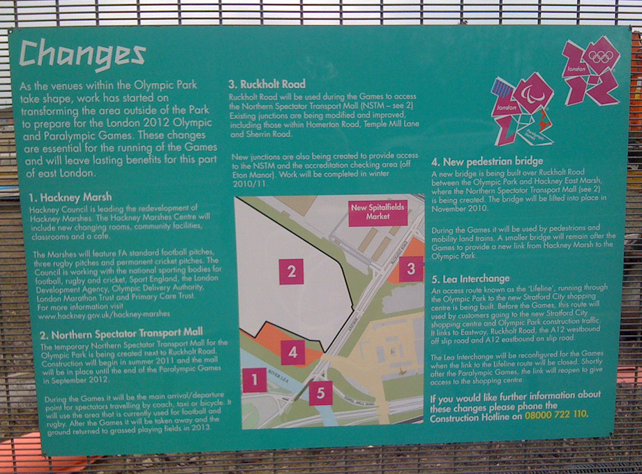
Lots of interesting information on here. As well as the “Hackney Marshes Centre” (aka South Marshes Community Hub) and the “Northern Spectator Transport Mall” (aka East Marsh) which I’ve covered before, there is mention of a new road – referred to as the “Lifeline” here, it is more specifically called the “Northern Retail Lifeline” in the Olympic Delivery Authority (ODA) planning documents I’ve dug up.
The Westfield Stratford City development was planned before the Olympics were awarded to London, and it always intended to open in 2011. As it stands, the triangular site is surrounded on two out of three sides by the huge Olympic construction site, and so would have been rather difficult to access upon opening, except from Stratford, until the Olympic security fences start to come down in 2013. To alleviate this poor access, the ODA was apparently obliged to provide a special access route from Walthamstow, Hackney and the A12 to the north, through the Olympic building site, to Stratford City.
The planning documents reveal some interesting information about the road.
Firstly, and most disappointingly, should I want to cycle over to Waitrose (this will not be the Stratford I know!) from Hackney Wick, I won’t be able to.
“NRL will only be for motor vehicles no larger than ‘4×4/SUV’ type vehicles. Furthermore, neither public transport nor pedestrians nor cyclists will be permitted”
Boo!
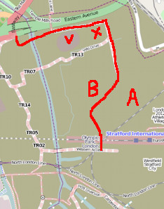 The road seems to start at the A12 junction, swinging sharply east and passing north of the newly completed Velodrome (V) and BMX track (X), before heading down to the Athlete’s Village (A). It then goes around the village boundary in an anticlockwise direction, passing the fluted white Basketball Arena (B) before heading straight down to join the Stratford City boundary. You can see much of the route in the plan here. I’ve drawn what I think is the whole route, on an OpenStreetMap on the right – also contains data CC-By-SA OpenStreetMap contributors.
At the north end of the road,
“The northern vehicle screening area, adjacent to the A12 Lea Interchange, will stop and check traffic” … “The security guard will indicate whether a vehicle has been selected by hand held signals and a display board.”
This sounds fairly involved, but in fact the security arrangements for Canary Wharf are rather similar and this hasn’t stopped it being rather popular.
There might be some bad news if you are disabled, as:
“The vehicle height restrictors will match the Stratford City car park restrictors of 2.2m. However, Stratford City allow 2.7m high vehicles on the ground floor for high sided disabled vehicles so these will not be able to exit or enter via the NRL.”
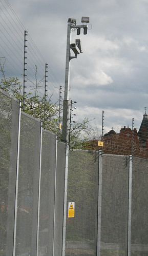 Once you are on the Lifeline road, don’t think about stopping for some nice close-up photos of the Velodrome, as this is not designed to be a welcoming road. The fence on either the side of the road:
“will be 3.6m high and does not include the standard power topping implemented on the Outer Perimeter Fence (OPF) across the majority of the Park.”
The “power topping” is a slightly euphemistic way of describing electric fences. Presumably the security checkpoints make the Lifeline a “partially secure zone” which is why they are deemed not required here.
Also:
“CCTV cameras will be mounted on extended fence posts every 40m at a height of 5.8m”
The road will open with Stratford City this autumn and then close again in June next year for the “Games lock down”, before presumably reopening while the rest of the park get transformed into post-Games mode.
The entrance to the Lifeline appears to be under intense construction at the moment – the Eastway road is a bit of a mess. East-bound cyclists have to walk a considerable distance along the pedestrian footpath. The Eastway is an important cycle link between Hackney and Leyton. It is set for improvement too though – I spotted another application for a dedicated cycle and footbridge further along to the east. The west-bound route is also a real mess currently, with a lot of weaving around various bits of construction – or braving it on the dual-carriageway.
 Some more interesting planning documents I found are this one which maps out the internal roads of the Olympic Park, and lists their names – Stadium Gardens, Handball Approach etc. Also, this letter outlines the plans for the park area west of the velodrome – the “North West Parklands”. Originally this was going to be a dramatic double crossing of the river by the cycle track – part of the “Velo Park”, but now, with the track being somewhat downgraded and placed east of the Velodrome, this is going to be more traditional open space, an “interim landscape zone” with presumably the eventual intent to build. There is a nice map here.
.jpg)
[Update: The somewhat depressing (in that apparently nothing good is ever done on site) Games Monitor blog spotted this a while back.]
11 replies on “Will this be Britain’s Most Secure Road?”
[…] me on a bike, as it’s the direct route from Hackney. Security here is polite but firm – only cars get to drive through the Olympic Park. I suspect the real reason cyclists and pedestrians can’t enter here is because there are no […]
That’s one use of the word monitor, yes. But there are other definitions of it too in common English usage, which do strongly suggest an NPOV, such as “keeping an eye on things” or “observing”.
I can’t agree with your comment on our use of the term monitor in our name.
Monitor is taken from the Latin: monitor (“warner”), from perfect passive participle monitus (“warning”), from verb monere (“to warn, admonish, remind”)
Our purpose of warning and admonishing that all is not as it seems is entirely appropriate. Neutrality is not required and not necessary. On the contrary a clearly stated position which makes no pretence of being neutral is desirable.
Steve – a name like “Monitor” implies in-depth detailed factual reporting from a neutral point of view, rather than a consistent negative bias. I do however absolutely support that there is an outlet taking a highly critical line, because as you say things will get swamped by (hopefully good) news as we get closer and closer.
I’m very local too, hence the stream of stories I’m writing about it at the moment.
Hi Ollie, In your update you say our GamesMonitor website is somewhat depressing (in that apparently nothing good is ever done on site). I’m sure you’ll admit there’s an overwhelming amount of goodnewsy spin around the Games, and that in fact it’s quite difficult to find a critical narrative? Our mission as locals who feel the other side of that process is quite simply to debunk some of those myths. Thanks for the plug though.
Ian, yes I need to update http://www.oobrien.com, it is properly old school at the moment.
PreS. I am almost certainly glad to hear it….
RE:B. “blog.oob…” certainly pushes the boundaries, but for me, “www.oob….” (which possibly should i have referred to as the back door, or the control room, or the map of maps of maps, or the bureau du directeur, rather than the front page, but i nevertheless arrived there first..) does appear beautifully simple and in a language i could almost understand.;, even in my other browser…
p.s. Normal orienteering service will be resumed shortly!
Ian, are you sure? The page should look pretty cutting edge. Try using a different browser, in case you have something bad cached.
Dear ollie, I see you are continuing with yet another wildly off-topic blog post. I will respond in kind: I see you have reverted to an old world look for the front page. this could almost be entirely understood by the same browser that understood my first web page. hope this helps,,,
I saw that sign on Hackney Marsh over the weekend, so I’m highly disappointed to discover that the ‘Lifeline’ route will never be used by pedestrians or cyclists.
Once local motorists discover that this road is their only chance to drive through the legendary Olympic Park, I wonder how many sightseers it’ll attract.
With the size of those fences it sounds a lot like a ride through a safari park, but with growling security guards instead of lions.