Some small updates to OpenOrienteeringMap:
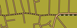
- Where trams run on or very near roads, they are now shown as being underneath the road. For the Street-O map, this means they are partially or completely obscured. On the Pseud-O map, a set of square dots shows where the tram goes. This stops the tram line from obscuring the (passable) road.

- Hedges are now drawn underneath the road layer, so they no longer obscure passable roads.

- Paths and tracks in tunnels (e.g. in shopping centres) are now shown on the Street-O map – previously they only appeared on Pseud-O.
Related Posts
-
Orienteering 2.0At tomorrow's City of London Race I'm trying something a bit interactive - a Twitter Wall and Photo Wall for the event. Tweet your photos and comments with hashtag #cityrace…
-
Orienteering PodcastsPlenty of orienteering weblogs out there now, including quite a few UK amateurs ones like YepSport. Blogs are so 2004 though, the current buzzword is of course podcasting. Think weblogs…
First (Real) Orienteering Podcast?Mat Dickinson has now posted a couple of short podcasts at OS Now, which I guess makes him the world's first second orienteer podcasting about the sport. Nice one! Now…