Here’s my planned mapping for the next extension to the City of London orienteering map:
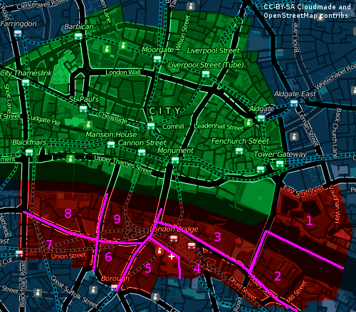
The plan is to do one of the nine sectors every three weeks between January and June next year.
The sectors are:
- St Katherine’s Docks
- Shad Thames
- Pool of London
- London Bridge Station
- Guy’s Hospital
- Borough
- Southwark
- Bankside
- Borough Market
5 replies on “Going South of the River”
Sounds interesting, I look forward to exploring and mapping it!
East of Mill Street looked quite boring but along the river and over the footbridge across the creek is magic – straight out of Oliver Twist so an excursion that way would be worthwhile
The mini housing estate at Perkins Square SE of the Globe looks useful – I can already see a nice little route choice leg from there to the Golden Hinde 🙂
I’ll try and have a look round east of Mill Street
Well I do know #7 a bit as both my parents were born and lived there. 🙂
There is definitely a subway from the NW corner of St Katherines across to Royal Mint Court. Plus some other links around there. But second step would be to get permission for St K. (first step is of course Southwark and More London)I like the sign. Somewhere around I have a picture I took of a sign on a very old bridge in Wool in Dorset. Basically it said “The penalty for damaging or defacing this bridge is transportation for life” !
East of Mill Street is a river inlet with a footbridge at one end and the road at the other. The Shad Thames conservation area does extend slightly east of here, roughly to the boundary I have drawn. Conservation areas are a good guide to “nice” or interesting areas for people to visit. This is also why I’ve proposed #6 and #7 for now, although these will indeed get mapped last for the reason you say. I incidentally haven’t been east of Mill Street either, except virtually in Google StreetView.
The area south of #4 is rather residential unfortunately. The current City Race map doesn’t have any residential areas on it at all, apart from the legendary Barbican of course.
Royal Mint Court sounds interesting but I don’t think there’s bridges/subways across the busy roads between it and the map.
This rather fantastic sign is at the southern edge of #7:
http://www.flickr.com/photos/oobrien/7707847/in/set-192775/
My thoughts so far…
Not sure that we will go into #6 or #7 because of busy road so definitely to be mapped later.
St Katherine’s is goimg to take special negotiation so I wouldn’t do anything with#1 until we get permission
Incidently, just to the north of that is Royal Mint Court, private but a nice set of buildings. Wiorth investigating as a link IF we get St Katherine’s
I plan to investigate south of #4 this Saturday. It looks like there may be a number of small parks there
Re #8. I don’t think that the map will stretch as far west as Blackfriars Bridge (and it’ll still have hoardings in place etc). But I reckon that it needs to go as far west as the Tate Modern so that there is scope to loop round to the park on the south side of it
Re #2. Is there anything useful to the east of Mill Street? (Never been there myself)
A