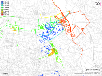
Recent changes I’ve made – Red/orange this weekend, green/yellow last week.
From my OpenStreetMap diary:
I’ve been making quite a few updates to East London recently, including:
- Mapping Queen Mary (University of London)‘s main Mile End Campus in detail, including all the buildings, the paths and other features. It was good to make use of a lot of first-hand knowledge I picked up (and the photos I took) when mapping the campus in the summer for an orienteering race.
- Adding building outlines and names for the main blocks in some of the housing estates around Hackney and Tower Hamlets.
- Adding in the detail for Mile End Park, which is alongside Queen Mary and was also part of the race. The Yahoo aerial imagery, and my own photographs, were very useful here.
- Mapping Hackney Wick, which is a curious enclave, quite a way from central Hackney and cut off from the rest of the borough by an ex-motorway, railway, river and canal. This included the maze of lanes and alleys that form the Trowbridge Estate (although I still don’t think I have it completely right) and the area to the south of the canal that is rapidly changing from industry to flats – although it has quite some way to go.
- Various updates along the route of London Cycle Route 8, which runs from Farringdon to Leyton. This included tagging/relating most of the route where it is waymarked, and updating the road layout along the route – adding various mini-roundabouts, cycle-only sections, and filling in De Beauvoir Square.
- Extending the 2012 Olympics site – the area that is sealed off by the distinctive blue walls now abutts Hackney Wick. I’ve also declassified all the roads in the park – they are now no-public-access service roads. Some of the roads have also been realigned or are completely dug up, and some of the railway lines have been bulldozed. I’ve added an outline for the main Olympic stadium, which is rapidly taking shape. Although I don’t have access to the park itself, there are a number of useful vantage points, including the Greenway, an elevated path that runs right through the site and is still open.
- As part of the above work on Hackney Wick and the Olympic site, I’ve deleted the A115. This road used to go from Hackney Wick to Stratford, however after a short stub into a housing/industrial estate at the Stratford end, the way is blocked by one of the 15 or so construction gates for the Olympic site. At the other end, the road similarly goes through quiet light industrial areas and then is blocked at a bridge. There are no signs visible for this road anywhere along its length or on roads approaching it, so it’s now downgraded.
- Adding the Mabley Green Boulder. Not quite sure how to classify this one – a large boulder that is an artwork but also a leisure/sporting facility. Osmarender is showing it a little too prominently at the moment.
- Adding in all the postboxes in the E9 postcode area (East Hackney), as part of the Dracos Locating Postboxes project.
- One non-London change – adding Rockall, based on some public-domain information and pictures. Funnily enough, I didn’t visit this one myself.