…was Google StreetView for London.
It’s already in several European cities, including Milan where Remo organised a virtual Street-O, and the StreetView camera cars have been spotted all over London.
Here’s hoping it will be going live Real Soon Now.
…was Google StreetView for London.
It’s already in several European cities, including Milan where Remo organised a virtual Street-O, and the StreetView camera cars have been spotted all over London.
Here’s hoping it will be going live Real Soon Now.
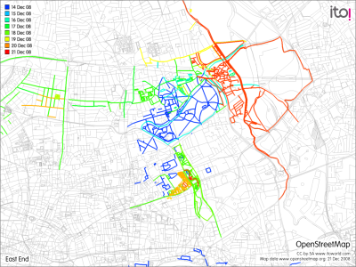
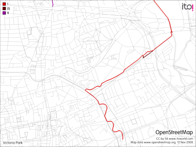
Recent changes I’ve made – Red/orange this weekend, green/yellow last week.
From my OpenStreetMap diary:
I’ve been making quite a few updates to East London recently, including:
The City of London race, held back in October, features prominently in the latest issues of British Orienteering‘s magazine, Focus – a competitor leaping over a wall outside the Gherkin is the cover photo, and there’s a two page article inside.
You can download the issue here.
The race will also has a five-page feature in CompassSport magazine’s next issue, which will be out in January.
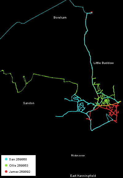
Instead of orienteering today, I organised a mapping party for UCL Geography. Three of us trekked out to Danbury, a historic village on a hill in Essex. Danbury lies just east of the extent of the high-resolution Yahoo aerial photography, so is almost completely unmapped. The village neatly splits into three main areas, so we each tackled one, by bike. After a couple of hours we retired to The Anchor pub for a late Sunday lunch – it was dark by the time we left, and very cold, so we skipped on mapping Little Baddow and headed back to upload the GPS data and add the topology to OpenStreetMap.
Here’s an automatically generated picture of our GPS traces for the day:
Here’s the Party Render animation, generated, like the picture above, from a very cool python script written by an OSMer:
My approach, from Chelmsford in the west and shown in green in the first picture above, was along National Cycle Route 1. As is often the case with the cycle network, it is not as direct as it could be.
The final result should appear on the main render on the OpenStreetMap website by Thursday.
I went to see this excellent public lecture at the IET (Institute of Engineering and Technology), given by the Curator of Timekeeping at the Royal Observatory. The presenter was clearly passionate about the subject and was full of interesting anecdotes and stories.
The lecture is online as a webcast (see the panel below) and well worth watching. It’s nearly two hours long including the questions, but if you are going to ever spend two hours watching a lecture, this is the one.
 |
Time by Wire: 175 years of the Greenwich Time Service David Rooney The Wheatstone Lecture 2008, London, UK 2008-12-03 05:33:48.0 News Channel |
(Note – the slides don’t show correctly if viewing with Safari, it works fine with Firefox though.)
BOF has this week started implementing the three-tier structure for 2009 orienteering events. What this means for the fixtures map is that all events from 1 January onwards are in category 2, 3 or 5. It’s difficult to spot the district-style events (i.e. the ones with 6 or so colour-coded courses) as they’ve all been renamed to local events, so a lot more clicking through to the event’s webpage is going to be needed to know whether there will be a Brown course or just short “training courses”.
In time, organisers may reclassify these to category 3 “regional” events (which in time will be renamed category 2, and category 2 events will be renamed category 1 – confused yet?!)
In short, during the transition phase, categories no longer reliably give an indication of the range of courses available. Of course, for city races and sprint races, this was already the case.
I’ve adjusted the code for the fixtures map – currently it fades level 5 events more than 60 miles away (100 miles for level 4 and 150 miles for level 3) on the table. It now fades level 4/5 events that are over 75 miles away.
John McKerrell has a new, free application on the iPhone App Store – it takes your current location and allows you submit the postcode for that location.
Why would you do this? It’s all about building a dataset of UK postcodes, in the public domain. The current database is owned by the Post Office, is expensive to license, and cannot be used without restrictions. Anything that helps build up a free-to-use set of UK data – particularly administrative and boundary data that is not physically obvious on the ground – is a Good Thing, as the current row between Google and the OS (more, more) about derived data shows.
I work with an academic team which is a major user of such data and such restrictions on use of this kind of data limit the way geographic and demographic research in the UK can be effectively disseminated to the public. Worries about viability of some of the bright ideas in Show Us A Better Way is a case in point.
So, if you have an iPhone, download the application and – next time you are, say, at a pub or a friend’s house, get adding locations! Or if you don’t have one, add them in on the NPE Map website.
My UK orienteering events fixtures map has steadily grown in popularity – from around 7,000 monthly views last December to 11,000 last month. The link from the national federation’s web page contributes to 40% of the incoming traffic, with Google second on 6%. The continued interest is encouraging, and I hope to spend some time around the Christmas break developing the site further, for instance adding an “I’m going!” link which might be useful in coordinating lift-shares, or listing the distance from the nearest railway station. Attackpoint already links the idea of events and members, and has member locations, but requires each member to add events manually.
One possible cloud on the horizon is the launch of BOF’s own updated fixtures list – this is apparently happening at the beginning of next year, and will almost certainly break the semi-automated process of updating my own list. Of course, if their new list includes similar functionality then that is a good thing.
I’d also like to develop the Map of Maps page further, perhaps making it a “Find my nearest club” service, where the most appropriate club is the one with the largest concentration of maps closest to you.
If you have any ideas for the fixtures map or the map of maps, please let me know in the comments below.
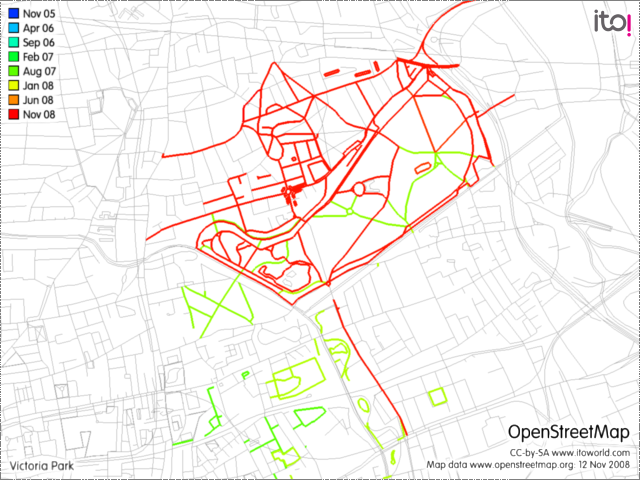
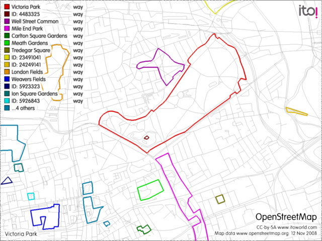
I went along to an interesting talk today, by Martin Dodge on user generated cartography, focusing on OpenStreetMap. One of the websites he showed was the ITO website, which has a mode where you can view OSM data, highlighted according to various filters.
Here’s a graphic from ITO showing the Victoria Park area of East London, with my own contributions highlighted. Click to see the full-size image:
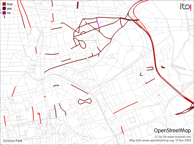
Here’s one showing all the ways tagged as being one-way streets. Looks like Hackney (to the north) is a lot more difficult to navigate in than Tower Hamlets (to the south):
This map shows the nearby National Cycle Network routes:
…and here’s where the parks are:
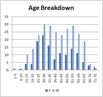
Here’s an age/gender breakdown of pre-entries from the City Race earlier this month:
It shows a good representation of “Open” class entrants – aged between 21 and 35, with the proportion of males-to-females reasonably balanced. There is the familiar participation dip, followed by the “baby boomer” surge – here, women are much more poorly represented.
This second graph looks at the ages of the non-affiliated entrants – those who didn’t list a club when entering. These people are most likely to be non-orienteering runners and other people new to the sport.
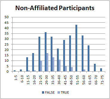
Again, participation is encouraging at the “Open” end, but there were almost no non-orienteering entrants to the race aged over 40.
Note that this data is on entrants rather than the people who took part on the race – anecdotally, many of the no-shows on the day were non-orienteering runners.