Categories
Leisure

London to Brighton – Again

I’ve already cycled from London to Brighton, but my new housemate suggested it on Saturday morning as it was such a nice day, so off we went.

The route and profile were pretty much the same time, so I won’t repeat them again here. The only variations were starting a couple of miles further back (as I’ve moved house), taking a pleasant detour through Tooting Park as Clapham High Street was closed, and not doing the kilometre-lengthening bit along Madeira Drive in Brighton itself. We also started earlier (just before midday) so the sun set this time when I was on the top of Ditchling Beacon, not at the bottom of it.

The traffic was noticeably busier, both in London and along the country lanes, which was a shame really – but using smaller roads would probably result in an even longer and hillier route. The cars going up and down the narrow road that climbs up Ditchling Beacon were particularly unpleasant.

Moving time was 5h 10 – slightly disappointingly taking 7 minutes longer than last year. However I was in considerably less pain this time and felt a lot fresher at the end – and didn’t get lost on the way from the sea-front to the station. Was too tired to get up early the following day though, so yet another weekend without orienteering.

ditchlingme

Categories
Leisure

London to Brighton

My housemate, who has only recently taken up cycling, cycled from London to Brighton on Sunday. Can’t be having that! So, I set off on Wednesday afternoon, quite late in the day, from home, with the aim of hopefully getting to Brighton, or at least a long way out of London, by sunset.

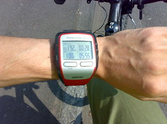
I did it! Although it did get pretty dark at the end. My route was exactly 100km, and took just over 5 hours moving time – adding in my many stops at traffic lights in London, a number of short rest breaks and a long (30 minute) break for lunch, I took 6h 20m. This was my longest ever day bike-ride – beating my 87km from Weston-super-Mare to Bath a couple of years ago.

At the Start - London to Brighton CourseMy route was copied from Adrian Fitch’s website: See here for the route, which I converted to TCX using the extremely excellent Bike Route Toaster and programmed it into my Garmin Forerunner 305 GPS, which then gave turn-by-turn instructions, with a countdown and a satisfying beep as I passed each junction. Apart from a couple of missed turns which I was soon alerted to, it worked very well – just as well, as I deliberately didn’t bring a map.

My route was very similar to the 2007 London to Brighton “official” cycle ride route, apart from my 13km prologue to get to the start. The only apparent differences are: (a) I cut off the Garratt Park corner just after Clapham Common, (b) I bypassed Hayward’s Heath to the east taking a route through Wivelsfield Green, and (c) I went over, rather than around, Hollingbury Hill on the outskirts of Brighton.

The worst section was going through south London – very stop-start. Carshalton, which I’ve never been to before, was very pretty though. There were a few big hills – getting through the North Downs, up Turner’s Hill, and up Ditchling Beacon, were the most notable ones. After the highest point (224m) it was a very nice, fast descent down into Brighton. I got caught in one rain shower, going through Ditchling village, but it stopped as I started the big ascent. It was pretty much dark as I hit the outskirts of Brighton. I’m pleased that I didn’t have to walk the bike up Ditchling Beacon – I was expecting it to be The Ultimate Challenge but it really wasn’t too bad in the end.

Taking my time from Clapham Common, which is where the official race starts (although their route is, as noted, slightly different) I did the 87 km in around 4h 25m, although this doesn’t include stops/breaks – with them, I took 5h 36m.

Next up will have to be the 2007 TDF Stage 1 route – although at >200km, I think I’ll need to do a truncated version.
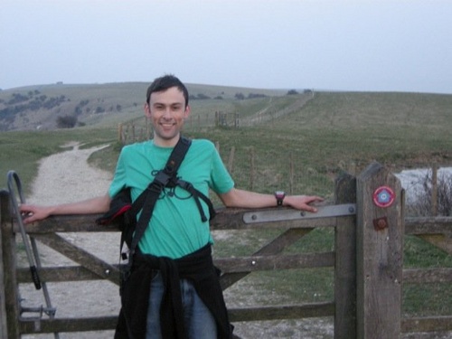
My photos.


Red is >25km/h, Blue is <15km/h

Categories
Leisure Munros

Hogmanay in Torridon

Descending

I had an unusual Hogmanay this year – up in Torridon with JOK. We stayed in Kinlochewe, by Loch Maree, and celebrated New Year itself at the Kinlochewe Hotel.

It turns out that quite a few JOKers are closet Munro-baggers. It was great to get out on the hills and climb some Munros, my first multi-day Munroing trip for nine years, I think. I climbed six new Munros, and also climbed Beinn Alligin again – this time, it was misty on the ridge, but still an exciting walk. I decided not to accompany some of the more dedicated Munroists on one of the days, when they climbed five of the Fannichs – not a bad round for midwinter. We didn’t have much in the way of snow, apart from on the way back on the last day.

I definitely need to get back and starting climbing Munros on a regular basis again. Why? Because “they are there.”

Photos from the trip – mostly taken with my cameraphone.
Day reports for the week – on my Attackpoint training journal.

I’m currently building a website that maps my climbed Munros, I will post about it in due course. I hope to eventually make it usable by anyone for tracking their Munro climbing.

Here’s some pseudo-3D geovisualisation of some of the routes we took. The pictures are screenshots from Google Earth, with my route shown in red, having been recorded with my Garmin Forerunner 305 GPS receiver. Not entirely coincidently, I spent Christmas evaluating a dissertation, an assessed part of my MSc course. The topic – Use of 3D geovisualisation to plan hiking routes. It was written before the days of Google Earth, so was quite prescient.

Beinn Alligin: December 31st

Our horseshoe route.

Our steep route down from the first Munro.<br /

Moruisg: January 2nd

Our route around Moruisg and the neighbouring Munro.

Looking along the ridge from the first summit.

Beinn Tarsuinn: January 3rd

Our route, looking from the A9 towards the summit.

View from above the summit, looking back along the approach route.

Categories
Leisure

Open Street Map: National Cycle Network Project

One project I’m contributing to is the Open Street Map. Gradually I’ve been adding detail around my local area – the East End of London. I’ve just bought a Garmin Forerunner 305 GPS receiver, to replace the one I lost a few weeks ago while out on a race. The Garmin will certainly be very useful for orienteering analysis, but it will also help with street mapping.

One project that’s caught my eye is a project to map the UK’s National Cycle Network. This network of cycle tracks and lanes throughout the country, was set up a few years ago by the Sustrans charity. Sustrans have their own GIS, but it is very slow and frustrating to use, and often out of date. The OSM project is aiming to come up with a “free” map of the network, using the power of Open Street Map and its flexibility and ease of contributing. Adding to the cycle map is simply a case of adding in the data to OSM in the normal way, then tagging the route with tags like “ncn_ref=1”.

It’s also a great way for me to justify doing some more long distance biking.

As a starter today, I noticed that National Cycle Route 1 (John o’Groats to Dover) is not marked for a short section between Hackney and Canary Wharf. I’m quite familiar with the route but I’m not 100% sure where it goes. So, I went out earlier today and biked along the section concerned, with my Garmin logging my route.

Here’s the corresponding trace. I’ve used it to add in the detail to OSM. With any luck, around a week from now, the newly tagged section of NCR 1, through London, will automagically appear on the OSM Cycle Map.

Categories
Leisure

2000km

Passed the 2000km mark on my bike, according to my cycle computer. Having done the first 1000km in 77 days, my second 1000km took 99 days. I’m only cycling in three days a week now since starting university, and I haven’t done many long bike rides this summer, as it hasn’t really been much of a summer…

Categories
Leisure

OSM Update

The rendering for my first mapping for Open Street Map project has now appeared on the online service:

Compare with what it was like before.

My next OSM contributions will be some alpine roads in northern Slovenia. I got some good GPS traces for many of the roads I travelled on during last week’s holiday. Here’s a Google Earth view of one of the traces (in blue) – note I’ve tilted the viewpoint so you can see the shape of the hills and why the road had so many hairpins:

Categories
Leisure

Open Street Map

I fixed my GPS yesterday, and finally got around to installing the mounting kit for my bike. As I’d missed my morning 5K time trial race, I thought I would finally get out on my bike and map the streets around where i live, for Open Street Map. This project is aiming to build a public-domain, copyright free map of the world. It was started by UK mapping enthusiasts and still has a lot of focus on the UK – its first conference was in Manchester last weekend, which is what got me thinking about it. I’ve been listening to the conference recordings over the last few days.

London in general has quite good coverage but there are plenty of gaps where I live, so I concentrated on my immediate local area. Execution consisted of cycling along all the streets – generally down the middle of them although swerving for cars – and photographing street signs for later annotation. My GPS recorded my position every second. Later I uploaded the GPS track to Open Street Map and then used the online Potlatch Flash map editor to add in, extend and annotate the streets. The results should appear on the main map within the next week – after then, parts of London E1 and E2 should be showing many more streets than before.

The first picture is from the editor, Potlatch. The lines in blue are my GPS tracks. The grey lines are roads I’ve added. One is selected, showing the attributes (in this case, the street name.) The satellite imagery in the background provides a useful check that the GPS tracks are accurate. The second picture is the equivalent view on the map itself – once my edits go through, this part of the map should look considerably more complete.


Categories
Leisure Orienteering

Why I Like the Bushy Park Time Trial more than most Orienteering Events

Oh dear. I had starting running in the Bushy Park Time Trial, a 5km trail race every Saturday at 9am in SW London, as a way to get me up and out of the house on mornings when there was no orienteering event. But now I’m choosing to go to it in preference to the very orienteering events I was looking to supplement.

Why? Because there’s a few things about it which beat any orienteering event:

  • It’s completely free.
  • You get your race photograph taken for free!
  • Results on the website normally within 3 hours of each race.
  • Photos on the website often within 6 hours of each race.
  • Stats galore on the website, including announcing personal of bests.
  • Personalised email sent automatically containing your result, performance statistics and motivational message.
  • No need to register before the event (unless it’s your first time) – just state your name at the finish.
  • No compulsory entry in advance.
  • Everyone runs the same course – men, women, children…
  • Free Lucozade sports drink at the finish, not generic Tesco Value orange squash.
  • Same price (free!) to run, whether you are affiliated to a club/a national govening body or not.
  • Sometimes get to run alongside (actually, a long way behind…) superstars of the sport at the same race.
  • Most race kits people run in aren’t overly garish.
  • No revisiting of areas you’ve already been to earlier in the race.
  • Proper, scenic spectator finish.
  • Start, finish and car park are all very close together.
  • Plenty of room to lock up bikes at the start.
  • Organised social at local coffee shop after each race.
  • Apparently occasional prizes and freebies, not that I’ve had any yet!
  • It has its own Facebook group.
  • The whole thing just feels friendly, relaxed and fun.

BPTT Photo of Me
Nice Try: I fail to make a 14 year old’s day by beating him in a sprint to the finish line. Still, we both got personal bests so he can’t be that unhappy. Photo by Paul SH.

Categories
Leisure

x-England Part 8

The Barge Inn

Completed, finally, my coast-to-coast bike ride across England, in eight stages. Coincidently I finished the last leg exactly a year after I started the first. The final stretch was the uphill one, from Bath to Bedwyn. After wandering around Bath, visiting the Royal Crescent, Victoria Circus and Pulteney Bridge, I headed along the canal, crossing the river by a couple of aquaducts, and passing through Avoncliffe (a real honey-pot), Bradford-upon-Avon, and Trowbridge. Then continuing along the canal, a more mundane section eventually led to the Caen Hill locks. An impressive sight, the 15 locks raise canal-boats by 72m. The cycle path continues right along the hill, before heading into Devizes at the top.

By now I was half-way along the day’s stage and quite tired, but had to pick up speed to make a train leaving Bedwyn in only a few hours. So I generally kept to faster roads rather than following National Cycle Route 4, which meanders all over the place, determined to keep cyclists to the most minor of roads, even going three sides of a square. Later I dropped back down onto the canal, visiting Crofton Pumping House in the gathering gloom at the very top of the canal (200m above sea-level) before dropping gratefully back into Bedwyn – it was very definitely dark now. There was just enough time to grab a much-needed pint in the village pub, and watch the local youth play chicken with 200km/h trains, before catching my own one back to London. Bedwyn is a nice, quiet village, and a fitting place to finish my ride.

The last section was particularly painful – 75km is a fair way, but I’ve definitely lost some fitness compared with earlier in the year. It was nice to test out my new mountain bike on a proper day-ride though, rather than just on the commute to work.

My favourite part of my whole route from Weston-super-Mare to Whitstable was the section across Windsor Great Park. The most unpleasant section was definitely Sittingborne in Kent.

The complete photo gallery, in geographic order, is here.

My next bike ride will be through the Downs and Weald from Crawley to Eastbourne, via Eridge, along National Route 21. Any one up for joining me? It’s around 45 miles long and is 80% on paths, so should be really enjoyable.

Categories
Leisure

x-England Part 7

Grand Pier (p710)

Last summer I managed to bike most of the way across England, starting from Bedwyn (near the watershed – the highest point of my route) and finishing in Whitstable in Kent. This summer I needed to finish the trip, in two long legs or three short legs from the west coast, back to Bedwyn.

Looking at the map, there was a quite a choice of places to start from. Avonmouth was one natural starting point, being at the mouth of the River Avon it would be quite apt as my route was essentially following the River Avon, then the Kennet and Avon canal, and finally the River Thames. However, Avonmouth doesn’t look like a particularly pretty place, and besides it’s all sealed off, being a major container port. Portishead and Clevedon were two other possible places, but neither was near a railway station. Brean Down has an intriguing footnote on the OS Map – “Mouth of the Severn”. This would be a natural place to start a coast-to-coast, but again it was not practical to get to. In the end I decided on Weston-super-Mare – a west coast beach resort which would contrast nicely with Whitstable’s east coast equivalent.

The National Cycle Routes guided me for most of the journey (Route 4 from Bristol to London and Route 1 from London to Whitstable) but annoyingly the network has not yet been built around Weston-super-Mare; so, after a stroll along the pier and through Weston Wood (a toll road!) the first part of the route was on country roads, and one unexpectadly exciting section off-road crossing the River Yeo – apart from the M5, it is difficult to cross this river without going a long way inland. I then headed up to Clevedon and then along a very pleasant country road only occasionally spoilt by the huge M5 suspended above it in places. I passed through the wonderfully named “Clapton in Gordano”, visiting its ex-church perched above the village in a beautiful setting. Then it was up the Avon Gorge, under the dramatic Clifton Suspension Bridge, and into Bristol centre, to meet up for the first time in a long time with a university friend, and to catch the England-Ecuador world cup game.

After the game, it was just starting to rain, but I had a train to get from Bath. So I headed through Bristol city centre, getting slightly lost before find the Bristol-Bath cycle bath. The path has a good surface and climbs only slightly gentle as it heads out of Bristol, through an exciting 700m long ex-railway tunnel before heading alongside another railway into Bath. I grabbed a meal in Bath and had a quick glance around the historic Abbey and Roman Baths, before getting the last train back to London.

At almost 85km, this was my longest day cycle ride ever, although only climbing 300m in that 85km means it’s got to be one of my flattest routes ever. Now only the final section, Bath to Bedwyn, remains – the section with pretty much all the climb up into the watershed.