ITOWorld have created a rather nice streetname error indicator layer for Great Britain, which graphically shows naming inconsistencies for streets, between OS Locator (part of the Ordnance Survey Open Data release) and OpenStreetMap, when using the latter’s editor tools.
The service uses rectangular bounding boxes to show the discrepancies. Initially I thought this would not work well, as streets that are aligned north-south or diagonally would dominate compared with streets aligned to the east-west axis, but actually it visually works well, regardless of the orientation.
Here’s a screenshot of what it looks like for a park of Hackney:
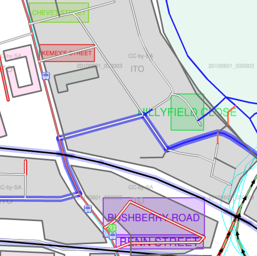
The light green square at the top is indicating “Chevet Street” – this is the OS Locator name, and clicking the road underneath the rectangle in the editor reveals it is called “Chevet Road” in the OpenStreetMap database. Similarly, the red square reads “Kemey’s Street”, while in OSM it is currently “Kemey Street”. The close in green on the right appears to be misnamed as an extension of the street it joins, while the two streets at the bottom aren’t named at all in OpenStreetMap – which is why they are also showing up as red in the editor. (The blue outline indicators one of the London Cycling Network routes, by the way.)
Time to get out on the streets and and clear these errors!
One reply on “OS Locator vs OSM”
[…] table, ITO produce a map showing the approximate location of each missing (or misspelled) road, as a rectangular bounding box. This makes finding the missing roads quite easy. Groundwork is needed to check signposts and […]