A couple of weeks ago, I went on one of the daily tours of the Olympic Park in London, organised by the Olympic Delivery Authority. Anyone can now go on these tours, rather than just local residents, but you do need to book a couple of months in advance. This summer is probably the best time to take the tour, as the “big build” of all the main venues is in its busiest phase. In theory, everything should be built by next summer, with a clear year to then test the venues.
The day I chose ended up being a grey and cold Sunday – not great for taking photographs – but it was still very worthwhile touring the site. The tours are on a single-decker bus, with a Blue Badge guide giving an interesting narration. After being picked up from Stratford and given a fold-out map of the site, we were then driven right around the A12 to Hackney Wick and the northern plaza entrance, where the bus was subjected to an elaborate sniffer-dog search, presumably just for show as the bus had already done several other tours on the day – and because we had no such check on re-entering the site from the southern plaza. It was a good opportunity for a safety and security briefing, though. (The northern plaza is where building materials are generally delivered – workers arrive several miles away at the southern plaza, generally from a DLR station there.)
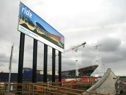
First up was the Velodrome, aka the Pringle because of the distinctive shape of its roof. It’s close to the northern edge of the site and is very visible from the A12. Beside it is a billboard with an illustration of how it will look when complete:
The Velodrome is one of the “Big 5” construction projects for the permanent buildings, along with the stadium, aquatic centre, athletes’ village and broadcast centre.
We then headed south, passing the basketball venue, a temporary building which has appeared from nowhere in just one month – already the “crazy paving” white plastic cladding is going on:
The Olympic Park isn’t the only building project going on in the area – along with Crossrail, the other big construction site is for the Stratford City Westfield development, which is more advanced and is due to open next year. A giant pedestrian bridge is being built between the two, and there is also a link road – the “Western Access”. The boundary between the two, with construction in all directions, is marked by a blue box:
The stadium is visible from the northern section we were in, but the main construction road was blocked due to some temporary works on one of the many bridges bisecting the numerous rivers, canals and channels in the site:
So we headed back onto the A12, around to Stratford, and back into the site through the southern plaza, an electronic sign there showing an impressive safety record:
Firstly, we went up close to the stadium itself, the basic shape of which is complete. The black section is the “temporary” section, although it might be around for longer than planned after the Olympics depending on what the stadium gets used for:
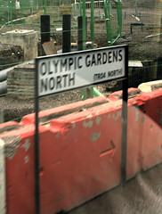
 We then went round to the eastern part of the site, where the aquatic centre is. On the way I spotted many of the road signs which have appeared on the site – as well as Olympic Gardens North and South, and Stadium Crescent East and West, I had earlier spotted Handball Way, Handball Approach, Velo Drive, Stadium Aquatics Link, Plaza Approach, Soc Highway, Waterden Road Works South, Wetlands Avenue East, H08 Diversion and the intriguingly named Norman Corner.
All of these signs are mounted on “permanent” metal signposts and look like regular street-name signs. Rather than also showing the first part of the postcode, and is traditionally done for London street-name signs, these signs include reference numbers starting with “TR”. (Trunk road?) I’ve added all the names I spotted to OpenStreetMap.
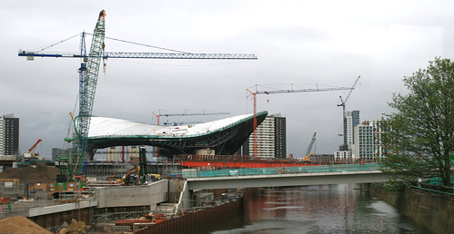
The aquatic centre is being built by first placing the roof on its supports, and then filling in the space beneath it. The dramatic Zaha Hadid wave shape of the roof looks brilliant up close:
From one angle, it appears to hang over one of the water channels:
From another, it looks like a futuristic space ship:
I headed back home along the Greenway, a raised route through the site, open to the public and the best way to see the site if you aren’t on the bus tour. Along the way, I noticed the mysterious concrete posts, that appeared a few months ago, have finally revealed their purpose – they are rather fancy signposts:
You can see more pictures I took in my Flickr album.


3 replies on “Inside the Olympic Park”
It’s presumably a play on “YouTube” – it’s a cafe and viewpoint for the stadium, made out of old shipping containers and painted bright green. It’s a great idea actually! See http://www.flickr.com/photos/oobrien/4488624748/in/set-72157623640056089/
What does “View Tube” point to? Is there a viewing gallery or stand for tourists wanting to see the London Underground?
[…] This post was mentioned on Twitter by IanVisits, Ollie. Ollie said: I've blogged about my recent Olympic Park tour: /2010/05/inside-the-olympic-park/ […]